EasternHops Community Forums

Show Posts

This section allows you to view all posts made by this member. Note that you can only see posts made in areas you currently have access to.


Messages - Pizza EAS-42oo

Pages: 1 ... 15 16 17 18 19 ... 23
241
"CESSNA 172 SUNDAYS" / "Northwest Mountain Hops" 11am EDT (RERUN)
« on: November 01, 2018, 12:23:10 PM »


Pick your favorite FSX Default Cessna Skyhawk 172
and join us on our "EasternHops CessnaSunday" Server
as we take you on an epic journey to Airports hops all around the world

Take-Off Time 11:00am ET/4pm gmt   
Join us on our Teamspeak server  "ts3.easternhops.com"

If you need help in any way use our "NEED HELP LET'S CHAT" on www.easternhops.com

Server name "EasternHops CesssnaSunday"   Server Password "onlycessna"

When using our E-Tracker (Smartcars) Charter System Flights should be
in the system all ready

Note; If you are using FTX Global Vectors there may be elevation profile update ask in Teamspeak for full information about this update


This week we will be flyin the   
>"Northwest Mountain Hops"< By Jt1199

SHORT LIST

CYXX-3W5-S52-0S7-CZGF-CAD4-KSZT-65S-88M-
CZPC-CYQL-KCTB-KGTF-7S6-KHWQ-KLWT-KRPX - 

=============================

STARTING AIRPORT   "Abbotsford / CYXX"
"

--------- ------------- ---------------- ------------- ---------


Figari (LFKF)

 " Abbotsford / CYXX"
Elevation 190 ft
Runway Length Surface ILS ID ILS Freq   ILS Hdg
01A 1500 Grass 
19A 1500 Grass
01 5260 Asphalt
19 5260 Asphalt
07 7988 Asphalt IXX 109.70 068
25 7988 Asphalt
===========================
Concrete Municipal (3W5)
Elevation 264 ft
Runway Length Surface ILS ID ILS Freq   ILS Hdg
07 2580 Asphalt
25 2580 Asphalt
===========================
Methow Valley State (S52)
Elevation 1694 ft
Runway Length Surface ILS ID ILS Freq   ILS Hdg
13 5044 Asphalt
31 5044 Asphalt
===========================
Scott
Elevation 1064 ft
Runway Length Surface ILS ID ILS Freq   ILS Hdg
15 4010 Asphalt
33 4010 Asphalt
===========================
Grand Forks
Elevation 1720 ft
Runway Length Surface ILS ID ILS Freq   ILS Hdg
07 1720 Asphalt
25 1720 Asphalt
===========================
Trail
Elevation 1420 ft
Runway Length Surface ILS ID ILS Freq   ILS Hdg
16 4000 Asphalt
34 4000 Asphalt
===========================
Sandpoint
Elevation 2131 ft
Runway Length Surface ILS ID ILS Freq   ILS Hdg
01 5495 Asphalt IRPO 109.10 016
19 5495 Asphalt
===========================
Boundary County Airport
Elevation 2333 ft
Runway Length Surface ILS ID ILS Freq   ILS Hdg
02 3995 Asphalt
20 3995 Asphalt
===========================
Eureka
Elevation 2668 ft
Runway Length Surface ILS ID ILS Freq   ILS Hdg
18 4200 Asphalt
36 4200 Asphalt
===========================
Pincher Creek
Elevation 3903 ft
Runway Length Surface ILS ID ILS Freq   ILS Hdg
07 6593 Asphalt
25 6593 Asphalt
===========================
Lethbridge
Elevation 3047 ft
Runway Length Surface ILS ID ILS Freq   ILS Hdg
05 6487 Asphalt IQL 109.50 056
23 6487 Asphalt
12 5496 Asphalt
30 5496 Asphalt
===========================
Cut Bank Municipal
Elevation 3854 ft
Runway Length Surface ILS ID ILS Freq   ILS Hdg
05 5289 Asphalt
23 5289 Asphalt
13 5294 Asphalt
31 5294 Asphalt
===========================
Great Falls Intl
Elevation 3677 ft
Runway Length Surface ILS ID ILS Freq   ILS Hdg
03 10487 Asphalt ISMR 111.30 031
21 10487 Asphalt
07 4285 Asphalt
25 4285 Asphalt
16 6353 Asphalt
34 6353 Asphalt
===========================
White Sulfur Springs
Elevation 5061 ft
Runway Length Surface ILS ID ILS Freq   ILS Hdg
01 6100 Asphalt
19 6100 Asphalt
13 3200 Grass
31 3200 Grass
===========================
Wheatland CO
Elevation 4311 ft
Runway Length Surface ILS ID ILS Freq   ILS Hdg
08 4200 Asphalt
26 4200 Asphalt
===========================
Lewistown
Elevation 4170 ft
Runway Length Surface ILS ID ILS Freq   ILS Hdg
02 5592 Asphalt
20 5592 Asphalt
07 6087 Asphalt
25 6087 Asphalt
12 4096 Asphalt
30 4096 Asphalt
===========================
Roundup
Elevation 3491 ft
Runway Length Surface ILS ID ILS Freq   ILS Hdg
06 5089 Asphalt
24 5089 Asphalt
15 2456 Grass
33 2456 Grass

===========================

From this point on pilots get to pick
airports at Random 30-40+ Hops
-----------------
---------

After this point airport will be picked at random 

SPREAD THE WORD AND TELL YOUR FRIENDS     
ANY QUESTIONS OR COMMENTS EMAIL us @ www.easternhops@gmail.com 
COME JOIN OUR NIGHTLY JET HOPS
 "Monday, Tuesday's relaxed HOPS with our VA tracking system -
 Random KingAir350 WEDNESDAYS" 
"Thunder Thursday's" and "Foggy Friday's"
Saturday " ATC / Hops " 
AND OUR MAIN EVENT OF THE WEEK "EASTERNHOPS CESSNA SUNDAY


Leg 1 >CYXX to 3W5 >R/wy ??
Leg 2 >3W5 to S52- >R/wy ??
Leg 3 >S52 to 0S7 >R/wy ??
Leg 4 >0S7 to CZGF > R/wy ??
Leg 5 >CZGF to CAD4> R/wy ??
Leg 6 >CAD4 to KSZT > R/wy ??
Leg 7 >KSZT to 65S- >R/wy ??
Leg 8 >65S to 88M >R/wy ??
Leg 9 >88M to CZPC> R/wy ??
Leg 10 >CZPC to CYQL> R/wy ??
Leg 11 >CYQL to KCTB-> R/wy ??
Leg 12 >KCTB- to KGTF->R/wy ??
Leg 13 >KGTF- to 7S6->R/wy ??
Leg 14 >KHWQ- to KLWT->R/wy ??
Leg 15 >KLWT- to KRPX->R/wy ??


242
EasternHops Virtual Airline / FLEET ROSTER
« on: October 31, 2018, 10:56:04 AM »


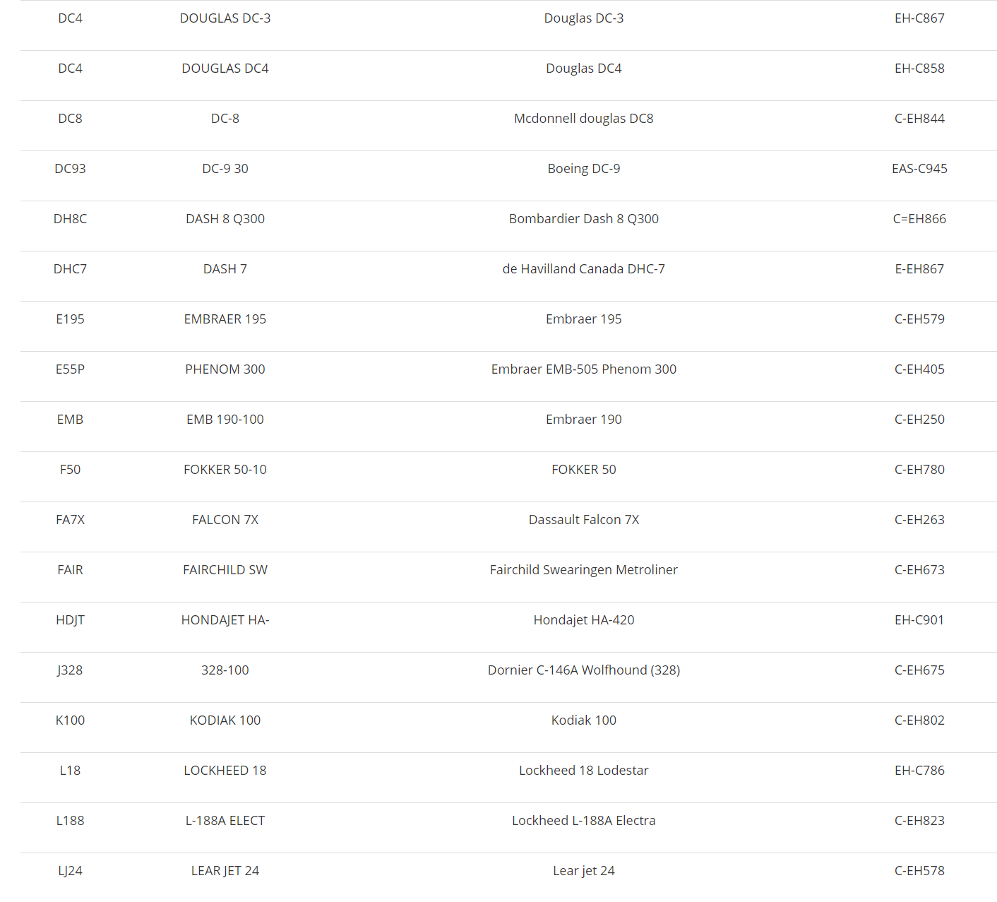
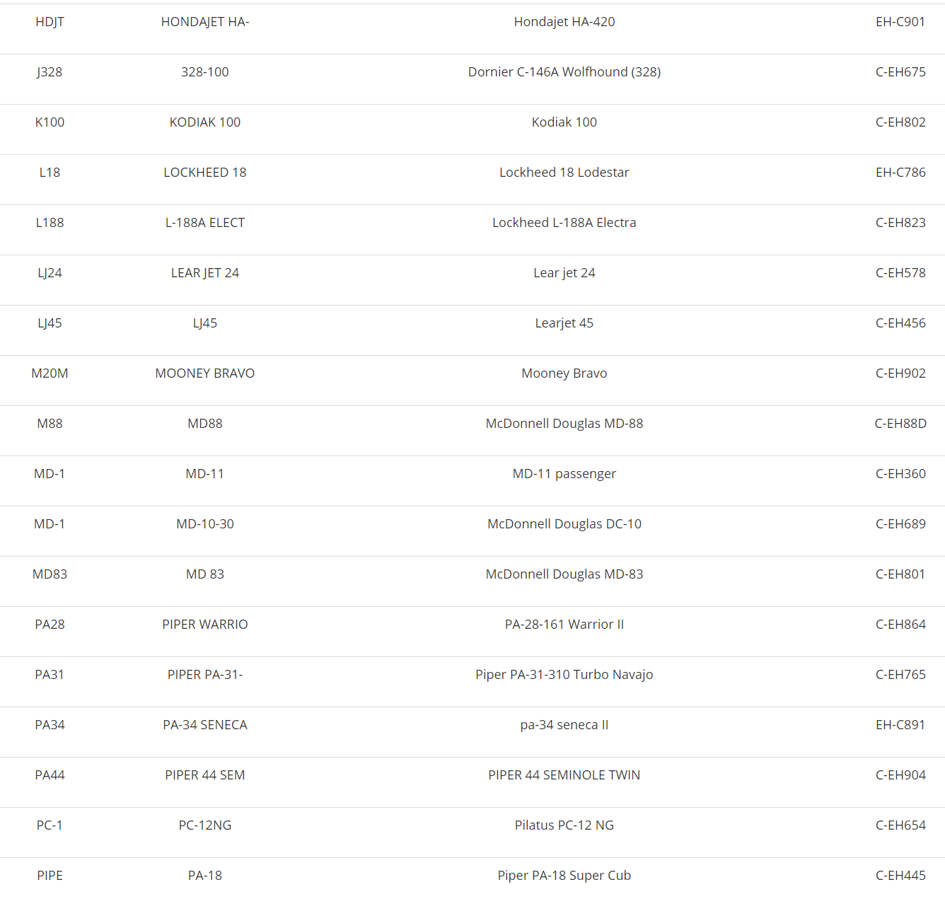
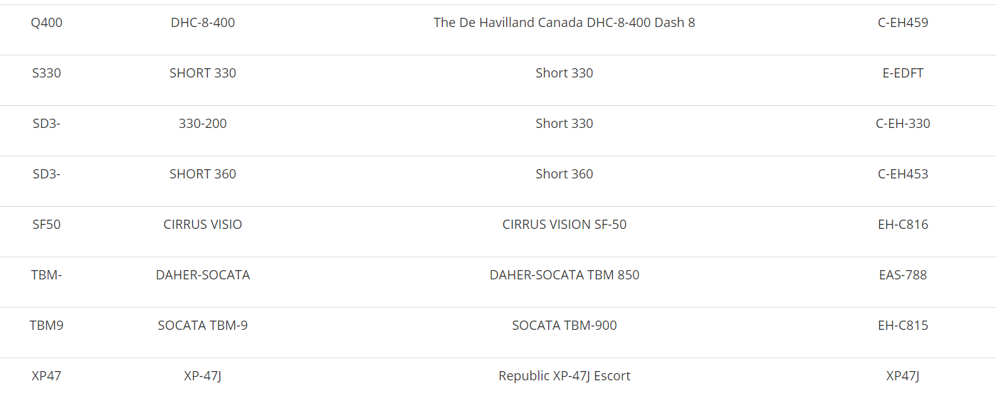
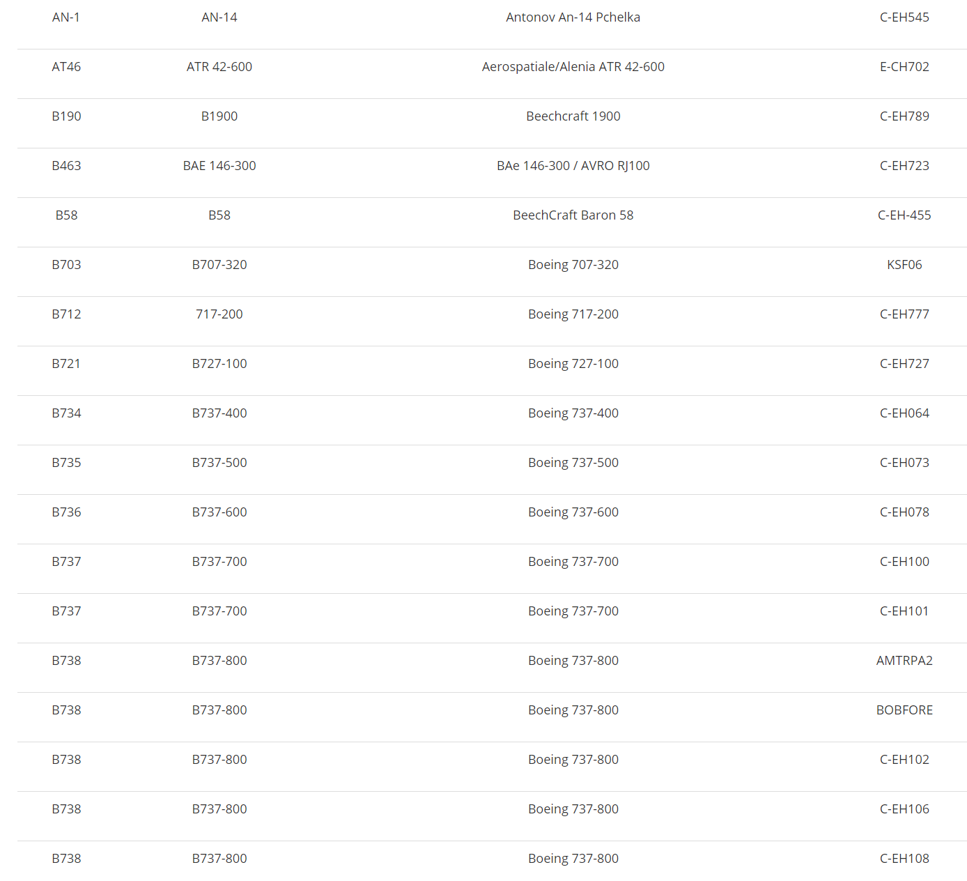
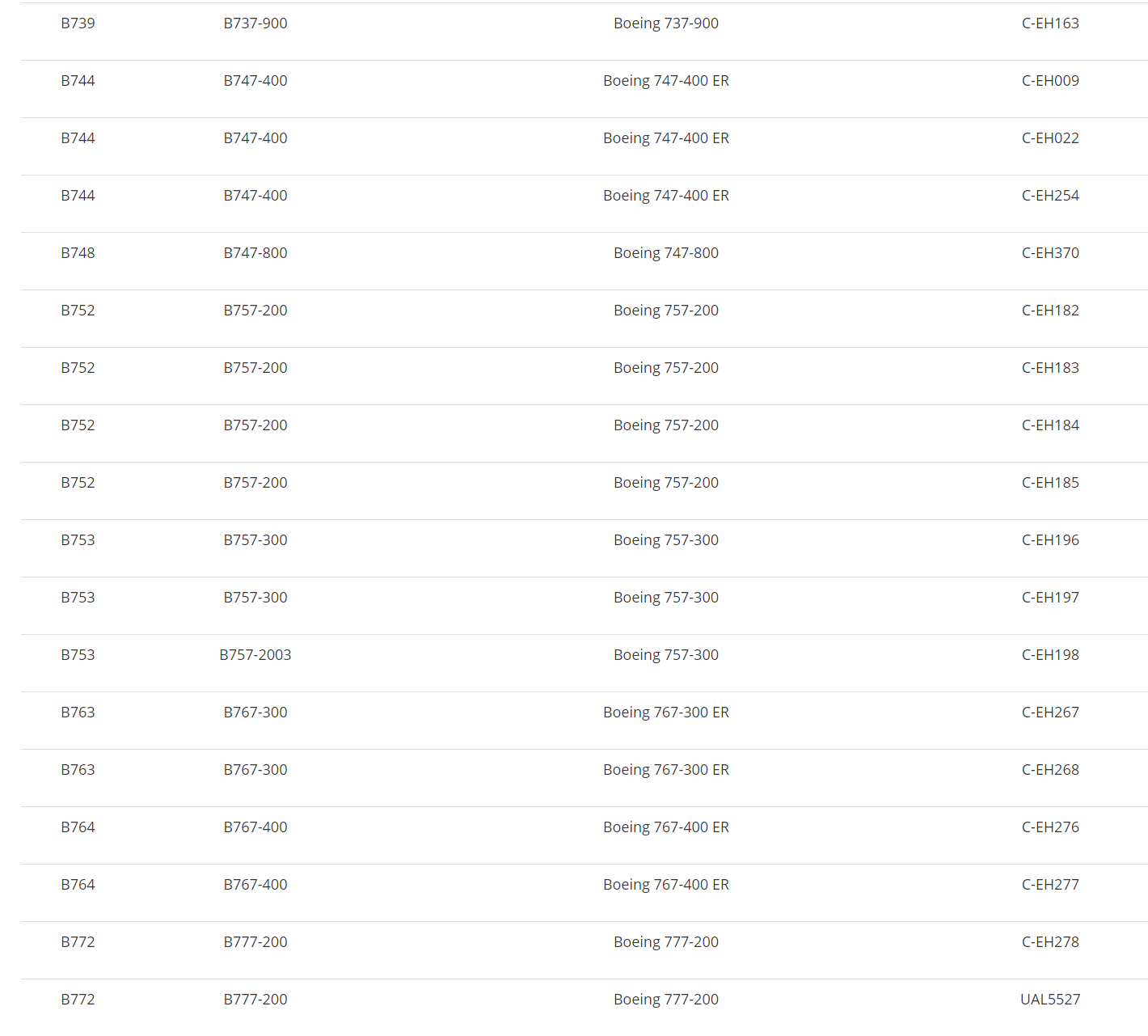
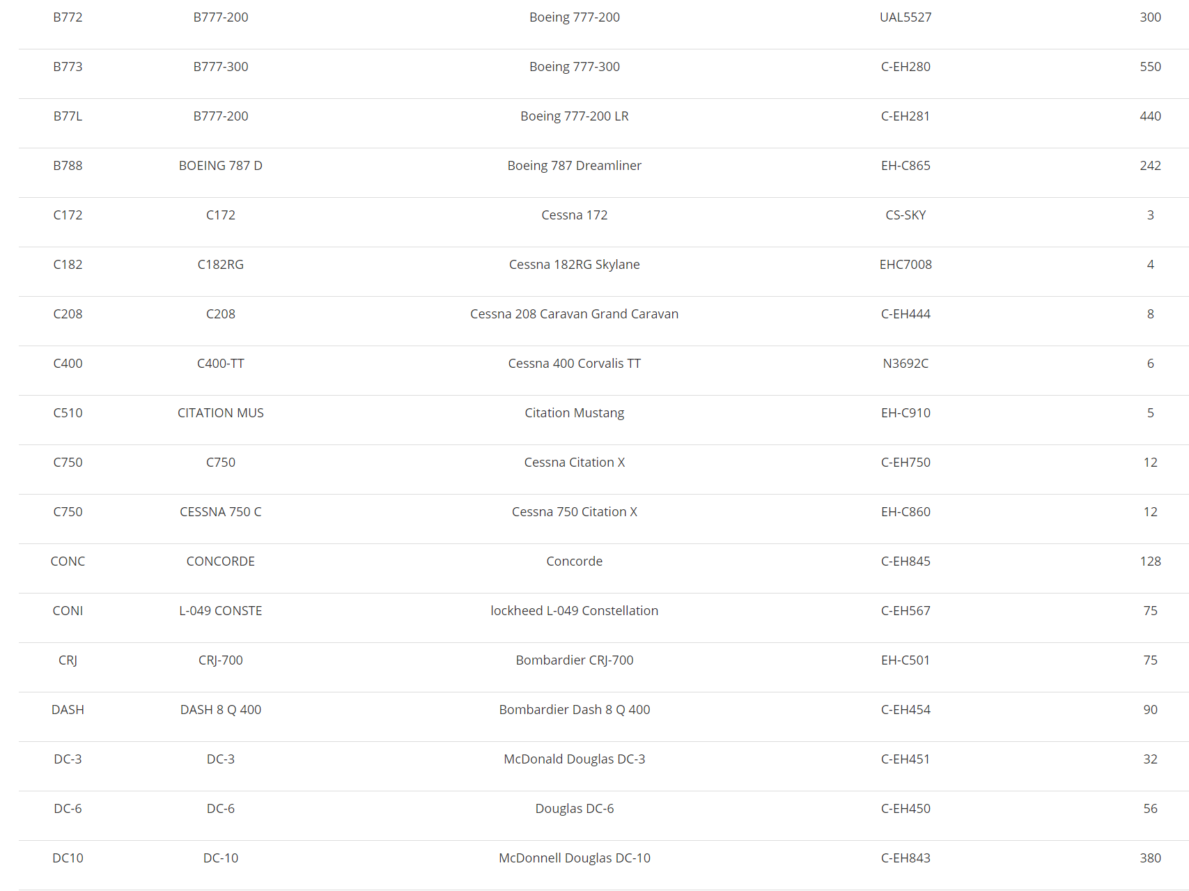
Below you can see what airplanes we have in our fleet, It will take 3 to 15 hours before you will be able to fly with them until then you can use a default aircraft. You can request an aircraft to be added HERE


----------------------------------

-----------------------------------

]
------------------------------------

------------------------------------
------------------------------------
------------------------------------
-------------------------------------

243


Pick your favorite FSX Default Cessna Skyhawk 172
and join us on our "EasternHops CessnaSunday" Server
as we take you on an epic journey to Airports hops all around the world

Take-Off Time 11:00am ET/4pm gmt   
Join us on our Teamspeak server  "ts3.easternhops.com"

If you need help in any way use our "NEED HELP LET'S CHAT" on www.easternhops.com

Server name "EasternHops CesssnaSunday"   Server Password "onlycessna"

When using our E-Tracker (Smartcars) Charter System Flights should be
in the system all ready

Note; If you are using FTX Global Vectors there may be elevation profile update ask in Teamspeak for full information about this update


This week we will be flyin the   
>>>"Italian Pasta Run"<<<

SHORT LIST

LFKF-LFKS-LFKC-LFKB-LIRJ-LIRS-LIRP-LIQW-LIQL-
LIRQ-LIQB-LIRZ-LIQN-LIRA-LIRH-LIRM-LIRN-LIRI - 

=============================

STARTING AIRPORT   "Figari/LFKF"
"

--------- ------------- ---------------- ------------- ---------


Figari (LFKF)

Elevation 87 ft
Runway   Length   Surface   ILS ID   ILS Freq   ILS Hdg
5   8132   Asphalt   
23   8132   Asphalt    GR   110.5      228
===========================
Solenzara (LFKS)

Elevation 28 ft
Runway   Length   Surface   ILS ID   ILS Freq   ILS Hdg
18   8623   Concrete  SZA   109.1      109.1
36   8623   Concrete
===========================
St. Catherine (LFKC)

Elevation 209 ft
Runway   Length   Surface   ILS ID   ILS Freq   ILS Hdg
18   7590   Concrete  CV   109.5      180
36   7590   Concrete
===========================
Poretta (LFKB)

Elevation 26 ft
Runway   Length   Surface   ILS ID   ILS Freq   ILS Hdg
16   8268   Concrete 
34   8268   Concrete  BP   111.35      342
===========================
Marina Di Campo (LIRJ)

Elevation 31 ft
Runway   Length   Surface   ILS ID   ILS Freq   ILS Hdg
16   3081   Asphalt
34   3081   Asphalt
===========================
Grosseto Mil (LIRS)

Elevation 15 ft
Runway   Length   Surface   ILS ID   ILS Freq   ILS Hdg
3   9822   Asphalt
21   9822   Asphalt
===========================
San Giusto (LIRP)

Elevation 6 ft
Runway   Length   Surface   ILS ID   ILS Freq   ILS Hdg
4L   9156   Asphalt
22R   9156   Asphalt
4R   9818   Asphalt   IPI   109.7      036
22L   9818   Asphalt
===========================
Luni Mil (LIQW)

Elevation 37 ft
Runway   Length   Surface   ILS ID   ILS Freq   ILS Hdg
18   2953   Asphalt
36   2953    Asphalt
===========================
Tassignano (LIQL)

Elevation 39 ft
Runway   Length   Surface   ILS ID   ILS Freq   ILS Hdg
10   2980   Asphalt
28   2980   Asphalt
===========================
Peretola (LIRQ)

Elevation 144 ft
Runway   Length   Surface   ILS ID   ILS Freq   ILS Hdg
5   5629   Macadam   IFZ   110.3      045
23   5629   Macadam
===========================
Arezzo (LIQB)

Elevation 814 ft
Runway   Length   Surface   ILS ID   ILS Freq   ILS Hdg
12   2165   Asphalt
30   2165   Asphalt
===========================
San Egidso (LIRZ)

Elevation 693 ft
Runway   Length   Surface   ILS ID   ILS Freq   ILS Hdg
1   5568   Bituminus  IPE   110.95      013
19   5568   Bituminus
============================
Rieti (LIQN)

Elevation 1276 ft
Runway   Length   Surface   ILS ID   ILS Freq   ILS Hdg
16R   2723   Grass
34L   2723   Grass
16L   2500   Grass
34R   2500   Grass
=============================
Ciampino (LIRA)

Elevation 427 ft
Runway   Length   Surface   ILS ID   ILS Freq   ILS Hdg
15   7242   Asphalt    CIA   109.9      152
33   7242   Asphalt
15L   7202   Asphalt
33R   7202   Asphalt
=============================
Frosinone (LIRH)

Elevation 645 ft
Runway   Length   Surface   ILS ID   ILS Freq   ILS Hdg
16   4736   Grass
34   4736   Grass
==============================
Grazzanise (LIRM)

Elevation 29
Runway   Length   Surface   ILS ID   ILS Freq   ILS Hdg
6   9735   Asphalt
24   9735   Asphalt
===============================
Capodichino (LIRN)

Elevation 294
Runway   Length   Surface   ILS ID   ILS Freq   ILS Hdg
6   8615   Macadam
24   8615   Macadam  INP   109.5      236
================================
Pontecagnano (LIRI)

Elevation 123 ft
Runway   Length   Surface   ILS ID   ILS Freq   ILS Hdg
5   4574   Asphalt
23   4574   Asphalt
===========================

From this point on pilots get to pick
airports at Random 30-40+ Hops
-----------------
---------

After this point airport will be picked at random 

SPREAD THE WORD AND TELL YOUR FRIENDS     
ANY QUESTIONS OR COMMENTS EMAIL us @ www.easternhops@gmail.com 
COME JOIN OUR NIGHTLY JET HOPS
 "Monday, Tuesday's relaxed HOPS with our VA tracking system -
 Random KingAir350 WEDNESDAYS" 
"Thunder Thursday's" and "Foggy Friday's"
Saturday " ATC / Hops " 
AND OUR MAIN EVENT OF THE WEEK "EASTERNHOPS CESSNA SUNDAY


Leg 1 >LFKF to LFKS >R/wy ??
Leg 2 >LFKS to LFKC- >R/wy ??
Leg 3 >LFKC to LFKB >R/wy ??
Leg 4 >LFKB to LIRJ > R/wy ??
Leg 5 >LIRJ to LIRS > R/wy ??
Leg 6 >LIRS to LIRP > R/wy ??
Leg 7 >LIRP to LIQW >R/wy ??
Leg 8 >LIQW to LIQL >R/wy ??
Leg 9 >LIQL to LIRQ >R/wy ??
Leg 10 >LIRQ to LIQB >R/wy ??
Leg 11 >LIQB to LIRZ >R/wy ??
Leg 12 >LIRZ to LIQN >R/wy ??
Leg 13 >LIQN to LIRA >R/wy ??
Leg 14 >LIRA to LIRH >R/wy ??
Leg 15 >LIRH to LIRM >R/wy ??
Leg 16 >LIRM to LIRN >R/wy ??
Leg 17 >LIRN to LIRI >R/wy ??


244


Pick your favorite FSX Default Cessna Skyhawk 172
and join us on our "EasternHops CessnaSunday" Server
as we take you on an epic journey to Airports hops all around the world

Take-Off Time 11:00am ET/4pm gmt   
Join us on our Teamspeak server  "ts3.easternhops.com"

If you need help in any way use our "NEED HELP LET'S CHAT" on www.easternhops.com

Server name "EasternHops CesssnaSunday"   Server Password "onlycessna"

When using our E-Tracker (Smartcars) Charter System Flights should be
in the system all ready

Note; If you are using FTX Global Vectors there may be elevation profile update ask in Teamspeak for full information about this update


This week we will be flyin the   
>>>"Scotland Fun Run"<<<

SHORT LIST

EGAE - EGAA - EGAD - EGNS - EGOY - EGEC - EGPK - EGPH -
EGPF - EGEO - EGPU - EGPR - EGPL - EGPE - EGPD - 

=============================

STARTING AIRPORT   "Eglinton (EGAE)"
"

--------- ------------- ---------------- ------------- ---------


Eglinton (EGAE)

Elevation:               22 FT

Runway   Length   Surface  ILS ID   ILS Freq ILS Hdg
2        3946     Asphalt
20       3946     Asphalt
8        6030     Asphalt
26       6030     Asphalt  IEGT     108.300   259

------------------------------------------------------------------------

Aldergrove (EGAA)

Elevation:               268 FT

Runway   Length   Surface  ILS ID   ILS Freq ILS Hdg
7        9100     Asphalt
25       9100     Asphalt  IAG      109.900   251
17       6194     Asphalt  IFT      110.900   168
35       6194     Asphalt

------------------------------------------------------------------------

Newtownards (EGAD)

Elevation:               9 FT

Runway   Length   Surface  ILS ID   ILS Freq ILS Hdg
4        2605     Asphalt
22       2605     Asphalt
8        1857     Tarmac
26       1857     Tarmac
16       2113     Asphalt
34       2113     Asphalt

------------------------------------------------------------------------

Isle Of Man (EGNS)

Elevation:               55 FT

Runway   Length   Surface  ILS ID   ILS Freq ILS Hdg
8        5803     Asphalt  IRH      111.150   087
26       5803     Asphalt  IRY      111.150   263
3        4017     Asphalt
21       4017     Asphalt
17       2963     Tarmac
35       2963     Tarmac

------------------------------------------------------------------------

West Freugh (EGOY)

Elevation:               57 FT

Runway   Length   Surface  ILS ID   ILS Freq ILS Hdg
6        6027     Asphalt
24       6027     Asphalt
12       2858     Asphalt
30       2858     Asphalt

------------------------------------------------------------------------

Campbeltown (EGEC)

Elevation:               44 FT

Runway   Length   Surface  ILS ID   ILS Freq ILS Hdg
11       9994     Asphalt
29       9994     Asphalt

------------------------------------------------------------------------

Prestwick (EGPK)

Elevation:               65 FT

Runway   Length   Surface  ILS ID   ILS Freq ILS Hdg
13       9778     Asphalt  IPP      110.300   126
31       9778     Asphalt  IKK      110.300   306
3        5991     Asphalt
21       5991     Asphalt

------------------------------------------------------------------------

Edinburgh (EGPH)

Elevation:               135 FT

Runway   Length   Surface  ILS ID   ILS Freq ILS Hdg
6        8384     Asphalt  IVG      108.900   064
24       8384     Asphalt  ITH      108.900   244
12       5919     Asphalt
30       5919     Asphalt
8        2684     Asphalt
26       2684     Asphalt

------------------------------------------------------------------------

Glasgow (EGPF)

Elevation:               26 FT

Runway   Length   Surface  ILS ID   ILS Freq ILS Hdg
5        8724     Asphalt  IUU      110.100   051
23       8724     Asphalt  IOO      110.100   231
10       3625     Asphalt
28       3625     Asphalt

------------------------------------------------------------------------

North Connel (EGEO)

Elevation:               20 FT

Runway   Length   Surface  ILS ID   ILS Freq ILS Hdg
1        4068     Asphalt
19       4068     Asphalt
3        2953     Asphalt
21       2953     Asphalt

------------------------------------------------------------------------

Tiree (EGPU)

Elevation:               38 FT

Runway   Length   Surface  ILS ID   ILS Freq ILS Hdg
5        4819     Asphalt
23       4819     Asphalt
11       2652     Asphalt
29       2652     Asphalt
17       1969     Concrete
35       1969     Concrete

------------------------------------------------------------------------

Barra (EGPR)

Elevation:               0 FT

Runway   Length   Surface  ILS ID   ILS Freq ILS Hdg
7        4916     Sand
25       4916     Sand
11       2184     Sand
29       2184     Sand
15       2771     Sand
33       2771     Sand

------------------------------------------------------------------------

Benbecula (EGPL)

Elevation:               19 FT

Runway   Length   Surface  ILS ID   ILS Freq ILS Hdg
17       3908     Asphalt
35       3908     Asphalt
6        6011     Bituminus
24       6011     Bituminus


------------------------------------------------------------------------
Inverness (EGPE)
Elevation:               31 FT
Runway   Length   Surface  ILS ID   ILS Freq ILS Hdg
5        6670     Asphalt  ILN      108.500   055
23       6670     Asphalt  IDX      108.500   235
12       2300     Asphalt
30       2300     Asphalt
1        3750     Asphalt
19       3750     Asphalt
13       950      Asphalt
31       950      Asphalt

===========================

From this point on pilots get to pick
airports at Random 30-40+ Hops
-----------------
---------

After this point airport will be picked at random 

SPREAD THE WORD AND TELL YOUR FRIENDS     
ANY QUESTIONS OR COMMENTS EMAIL us @ www.easternhops@gmail.com 
COME JOIN OUR NIGHTLY JET HOPS
 "Monday, Tuesday's relaxed HOPS with our VA tracking system -
 Random KingAir350 WEDNESDAYS" 
"Thunder Thursday's" and "Foggy Friday's"
Saturday " ATC / Hops " 
AND OUR MAIN EVENT OF THE WEEK "EASTERNHOPS CESSNA SUNDAY


Leg 1 >EICK . to EIKY>R/wy ??
Leg 2 >EIKY to EINN- >R/wy ??
Leg 3 >EINN to EIIR >R/wy ??
Leg 4 >EIIR to EICM > R/wy ??
Leg 5 >EICM to EIKN> R/wy ??
Leg 6 >EIKN to EISG > R/wy ??
Leg 7 >EISG to EGAB- >R/wy ??
Leg 8 >EGAB to EGAE >R/wy ??
Leg 9 >EGAE to EGAA > R/wy ??
Leg 10 >EGAA to EGAD> R/wy ??
Leg 11 >EGAD to EGNS > R/wy ??
Leg 12 >EGNS to EGOY >R/wy ??
Leg 13 >EGOY to EGEC >R/wy ??
Leg 14 >EGEC to EGPK > R/wy ??
Leg 15 >EGPK to EGPH > R/wy ??
Leg 16 >EGPH to EGPF > R/wy ??
Leg 17 >EGPF to EGEO>R/wy ??
Leg 18 >EGEO to EGPU- >R/wy ??
Leg 19 >EGPU to EGPR >R/wy ??
Leg 20 >EGPR to EGPL > R/wy ??
Leg 21 >EGPL to UK10> R/wy ??
Leg 22 >UK10 to EGPD > R/wy ??


245


Pick your favorite FSX Default Cessna Skyhawk 172
and join us on our "EasternHops CessnaSunday" Server
as we take you on an epic journey to Airports hops all around the world

Take-Off Time 11:00am ET/4pm gmt   
Join us on our Teamspeak server  "ts3.easternhops.com"

If you need help in any way use our "NEED HELP LET'S CHAT" on www.easternhops.com

Server name "EasternHops CesssnaSunday"   Server Password "onlycessna"

When using our E-Tracker (Smartcars) Charter System Flights should be
in the system all ready

Note; If you are using FTX Global Vectors there may be elevation profile update ask in Teamspeak for full information about this update


This week we will be flyin the   
>>>"Mexico to Cuba Run"<<<

SHORT LIST

MMCT-MMCZ-MMUN-MUSJ-MULM-MUNG-MUSA-MUNB-MUVR-MUCF-MUSC

=============================

STARTING AIRPORT   "Chichen-Itza (MMCT)"
"

--------- ------------- ---------------- ------------- ---------


Chichen-Itza (MMCT)
Tower:                   118.900 MHz
Elevation:               102 FT
Runway   Length   Surface  ILS ID   ILS Freq ILS Hdg
10       9177     Asphalt
28       9177     Asphalt
===========================
Cozumel Intl (MMCZ)
Elevation:               15 FT
Runway   Length   Surface  ILS ID   ILS Freq ILS Hdg
11       8847     Asphalt
29       8847     Asphalt
5        8184     Asphalt
23       8184     Asphalt
===========================
Cancun Intl (MMUN)
ATIS:                    127.700 MHz
Elevation:               20 FT
Runway   Length   Surface  ILS ID   ILS Freq ILS Hdg
12       11497    Asphalt  ICUN     111.100   122
30       11497    Asphalt
===========================
San Julian (MUSJ)
Elevation:               98 FT
Runway   Length   Surface  ILS ID   ILS Freq ILS Hdg
8        8497     Asphalt
26       8497     Asphalt
1        7037     Asphalt
19       7037     Asphalt
===========================
La Coloma (MULM)
Elevation:               131 FT
Runway   Length   Surface  ILS ID   ILS Freq ILS Hdg
7        6560     Asphalt
25       6560     Asphalt
===========================
Rafael Cabrera (MUNG)
Elevation:               79 FT
Runway   Length   Surface  ILS ID   ILS Freq ILS Hdg
5        8212     Asphalt
23       8212     Asphalt
17       5346     Asphalt
35       5346     Asphalt
===========================
San Antonio De Los Banos (MUSA)
Elevation:               164 FT
Runway   Length   Surface  ILS ID   ILS Freq ILS Hdg
1        7873     Concrete
19       7873     Concrete
5        11799    Concrete
23       11799    Concrete
12       8144     Concrete
30       8144     Concrete
===========================
San Nicolas De Bari (MUNB)
Elevation:               49 FT
Runway   Length   Surface  ILS ID   ILS Freq ILS Hdg
6        3300     Asphalt
24       3300     Asphalt
===========================
Juan G. Gomez Intl (MUVR)
Elevation:               210 FT
Runway   Length   Surface  ILS ID   ILS Freq ILS Hdg
6        11497    Asphalt  IVR      111.300   060
24       11497    Asphalt
===========================
Jaime Gonzalez (MUCF)
Elevation:               102 FT
Runway   Length   Surface  ILS ID   ILS Freq ILS Hdg
2        7902     Asphalt
20       7902     Asphalt
===========================
Abel Santamaria (MUSC)
Elevation:               338 FT
Runway   Length   Surface  ILS ID   ILS Freq ILS Hdg
8        9895     Asphalt
26       9895     Asphalt
===========================

From this point on pilots get to pick
airports at Random 30-40+ Hops
-----------------
---------

After this point airport will be picked at random 

SPREAD THE WORD AND TELL YOUR FRIENDS     
ANY QUESTIONS OR COMMENTS EMAIL us @ www.easternhops@gmail.com 
COME JOIN OUR NIGHTLY JET HOPS
 "Monday, Tuesday's relaxed HOPS with our VA tracking system -
 Random KingAir350 WEDNESDAYS" 
"Thunder Thursday's" and "Foggy Friday's"
Saturday " ATC / Hops " 
AND OUR MAIN EVENT OF THE WEEK "EASTERNHOPS CESSNA SUNDAY


Leg 1 >MMCT to MXA4 >R/wy ??
Leg 2 >MXA4 to MMCZ- >R/wy ??
Leg 3 >MMCZ to MMUN >R/wy ??
Leg 4 >MMUN to MUSJ > R/wy ??
Leg 5 >MUSJ to MULM> R/wy ??
Leg 6 >MULM to MUNG > R/wy ??
Leg 7 >MUNG to MUSA- >R/wy ??
Leg 8 >MUSA to MUNB >R/wy ??
Leg 9 >MUNB to MUVR> R/wy ??
Leg 10 >MUVR to MUCF> R/wy ??
Leg 11 >MUCF to MUSC-> R/wy ??


246

Pick your favorite FSX Default Cessna Skyhawk 172
and join us on our "EasternHops CessnaSunday" Server
as we take you on an epic journey to Airports hops all around the world

Take-Off Time 11:00am ET/4pm gmt   
Join us on our Teamspeak server  "ts3.easternhops.com"

If you need help in any way use our "NEED HELP? LET'S CHAT" on www.easternhops.com

Server name "EasternHops CesssnaSunday"   Server Password "onlycessna"

When using our E-Tracker (Smartcars) Charter System Flights should be in the system allready so do a search through the E-Tracker Before you create a flight on the website...Thanks ask if you are not sure

Note; If you are using FTX Global Vectors there is an elevation profile update (K) ask in Teamspeak for full information about this update


This week we will be flyin the   
>>" SMOKEY MOUNTAIN RUN"<By Steff EAS-313<

SHORT LIST

KAVL-2NC0-KGCY-NC06-KGEV-KUKF-KMWK-KGSO-KHLX-KBCB-KLWB-KSXL-KEKN

=============================
STARTING AIRPORT >>"ASHEVILLE REGIONAL (KAVL)"
--------- ------------- ---------------- ------------- ---------

Asheville Regional (KAVL)

Elevation 2165
Runway   Length   Surface     ILS ID   Freq   ILS Hdg
16   8011   Asphalt       IIMD    110.9   165
34   8011   Asphalt     IAVL    110.5   345
===========================
Mountain Air (2NC0)

Elevation 4432
Runway   Length   Surface      ILS ID   Freq   ILS Hdg
14   2900    Asphalt
32   2900   Asphalt
===========================
Greenville-Greene Co. Muni (KGCY)

Elevation 1608
Runway   Length   Surface      ILS ID   Freq   ILS Hdg
5   6301   Asphalt    IGCY     108.5   051
23   6301   Asphalt
===========================
Elk River (NC06)

Elevation 3468
Runway   Length   Surface      ILS ID   Freq   ILS Hdg
12   4600   Asphalt
30   4600   Asphalt
===========================
Ashe Co. (KGEV)

Elevation 3180
Runway   Length   Surface      ILS ID   Freq   ILS Hdg
10   4288   Asphalt
28   4288   Asphalt    IJUK     109.35   274
===========================
Wilkes Co. (KUKF)

Elevation 1305
Runway   Length   Surface      ILS ID   Freq   ILS Hdg
1   6209   Asphalt    IUKF     111.55  005
19
===========================
Mt. Airy/Surry Co. (KMWK)

Elevation 1247
Runway   Length   Surface      ILS ID   Freq   ILS Hdg
18   4307   Asphalt
36   4307   Asphalt
===========================
Piedmont Triad (KGSO)

Elevation 926
Runway   Length   Surface      ILS ID   Freq   ILS Hdg
5   10,000   Asphalt      ILZY     111.9   052
23      10,000   Asphalt    IHIH     109.3   232
14    6381   Asphalt    IGSO     109.9   141
32    6381     Asphalt
===========================
Twin Co. (KHLX)

Elevation 2693
Runway   Length   Surface      ILS ID   Freq   ILS Hdg
18   4207   Asphalt
36   4207   Asphalt
===========================
Virginia Tech/Montgomery Exec. (KBCB)

Elevation 2132
Runway   Length   Surface      ILS ID   Freq   ILS Hdg
12   4535   Asphalt    IBCB     109.1   124
30   4535   Asphalt
===========================
Greenbrier Valley (KLWB)

Elevation 2302
Runway   Length   Surface      ILS ID   Freq   ILS Hdg
4   7004   Asphalt    ILWB       110.35   045
22   7004   Asphalt
===========================
Summerville (KSXL)

Elevation 1987
Runway   Length   Surface      ILS ID   Freq   ILS Hdg
4   3015   Asphalt    SXL      110.1   038
22
===========================
Elkins-Randolph Co. (KEKN)

Elevation 1987
Runway   Length   Surface      ILS ID   Freq   ILS Hdg
14   4540   Asphalt
32   4540   Asphalt
5   4500   Asphalt
23   4500   Asphalt     IOUW    109.9   195

-----------------------------

From this point on pilots get to pick
airports at Random 30-40+ Hops
-----------------


SPREAD THE WORD AND TELL YOUR FRIENDS     
ANY QUESTIONS OR COMMENTS EMAIL us at operations@easternhops.com
https://easternhops.com/community/index.php/ "Lets talk" support
COME JOIN OUR NIGHTLY JET HOPS
 "Monday, Tuesday's relaxed HOPS with our VA tracking system -
  Random KingAir WEDNESDAYS" 
"Thunder Thursday's" and "Foggy Friday's"
Saturday " ATC / Hops " 
AND OUR MAIN EVENT OF THE WEEK "EASTERNHOPS Cessna Sundays"

BE SURE TO LIKE AND SHARE OUR SOCIAL MEDIA

Youtube Channel

Robert easternHops FaceBook


EasternHops Community Facebook


EasternHops Flight Radio FaceBook

Leg 1 >KAVL to 2NC0  >R/wy ??
Leg 2 >2NC0 to KGCY- >R/wy ??
Leg 3 >KGCY to NC06  >R/wy ??
Leg 4 >NC06 to KGEV  >R/wy ??
Leg 5 >KGEV to KUKF  >R/wy ??
Leg 6 >KUKF to KMWK  >R/wy ??
Leg 7 >KMWK to KGSO  >R/wy ??
Leg 8 >KGSO to KHLX  >R/wy ??
Leg 9 >KHLX to KBCB  >R/wy ??
Leg 10 >KBCB to KLWB >R/wy ??
Leg 11 >KLWB to KSXL >R/wy ??
Leg 12 >KSXL-to KEKN >R/wy ??


247


Pick your favorite FSX Default Cessna Skyhawk 172
and join us on our "EasternHops CessnaSunday" Server
as we take you on an epic journey to Airports hops all around the world

Take-Off Time 11:00am ET/4pm gmt   
Join us on our Teamspeak server  "ts3.easternhops.com"

If you need help in any way use our "NEED HELP LET'S CHAT" on www.easternhops.com

Server name "EasternHops CesssnaSunday"   Server Password "onlycessna"

When using our E-Tracker (Smartcars) Charter System Flights should be
in the system all ready

Note; If you are using FTX Global Vectors there may be elevation profile update ask in Teamspeak for full information about this update


This week we will be flyin the   
>>>"BAHAMAS Banana Bash Up"<<<

SHORT LIST

MYGW-MTGF-MYGM-MYAT-MYAM-MYAS-MYBG-MYNN-
MYAF-MYAK-MYES-MYEF-MYEG-MYLD-MYLS-MYE5-MYSM

=============================

STARTING AIRPORT   "West End / MYGW"
"

--------- ------------- ---------------- ------------- ---------


West End    MYGW

Elevation - 5ft
Runway   Length   Surface   ILS ID   ILS FREQ   ILS Hdg
11   8000   Asphalt
29   8000   Asphalt
17   6200   Asphalt
35   6200   Asphalt
===========================
Grand Bahama Intl.    MYGF

Elevation - 7ft
Runway   Length   Surface   ILS ID   ILS FREQ   ILS Hdg
6   11020   Asphalt   IZFP   109.7      065
24   11020   Asphalt
===========================
Grand Bahama Aux   MYGM

Elevation - 8ft
Runway   Length   Surface   ILS ID   ILS FREQ   ILS Hdg
5   7200   Asphalt
23   7200   Asphalt
===========================
Treasure Cay       MYAT

Elevation - 8ft
Runway   Length   Surface   ILS ID   ILS FREQ   ILS Hdg
14   7008   Asphalt
32   7008   Asphalt
===========================
Marsh Harbor      MYAM

Elevation - 6ft
Runway   Length   Surface   ILS ID   ILS FREQ   ILS Hdg
9   4995   Asphalt
27   4995   Asphalt
===========================
Sandy Point      MYAS

Elevation - 8ft
Runway   Length   Surface   ILS ID   ILS FREQ   ILS Hdg
10   3000   Coral
28   3000   Coral
===========================
Great Harbor Cay   MYBG

Elevation - 18ft
Runway   Length   Surface   ILS ID   ILS FREQ   ILS Hdg
13   4536   Asphalt
31   4536   Asphalt
===========================
Nassau         MYNN

Elevation - 16ft
Runway   Length   Surface   ILS ID   ILS FREQ   ILS Hdg
9   8318   Asphalt   
27   9318   Asphalt
14   11031   Asphalt   IZQH   110.1       141   
===========================
Andros Town      MYAF

Elevation - 5ft
Runway   Length   Surface   ILS ID   ILS FREQ   ILS Hdg
9   4000   Asphalt
27   4000   Asphalt
===========================
Congo Town      MYAK

Elevation - 15ft
Runway   Length   Surface   ILS ID   ILS FREQ   ILS Hdg
10   5300   Asphalt
28   5300   Asphalt
===========================
Staniel Cay      MYES

Elevation - 5ft
Runway   Length   Surface   ILS ID   ILS FREQ   ILS Hdg
17   3030   Asphalt
35   3030   Asphalt
===============================
Exuma Intl      MYEF

Elevation - 9ft
Runway   Length   Surface   ILS ID   ILS FREQ   ILS Hdg
12   7053   Asphalt
30   7853   Asphalt
=============================
George Town      MYEG

Elevation - 6ft
Runway   Length   Surface   ILS ID   ILS FREQ   ILS Hdg
11   5000   Asphalt
29   5000   Asphalt
==============================
Deadmans Cay      MYLD

Elevation - 9ft
Runway   Length   Surface   ILS ID   ILS FREQ   ILS Hdg
9   4000   Asphalt
27   4000   Asphalt
==============================
Stella Maris      MYLS

Elevation - 10ft
Runway   Length   Surface   ILS ID   ILS FREQ   ILS Hdg
13   4300   Asphalt
31   4300   Asphalt
===============================
Rum Cay         MYE5

Elevation - 11ft
Runway   Length   Surface   ILS ID   ILS FREQ   ILS Hdg
13   2400   Coral
31   2400   Coral
================================
San Salvador      MYSM

Elevation - 24ft
Runway   Length   Surface   ILS ID   ILS FREQ   ILS Hdg
10   7996   Asphalt
28   7996   Asphalt

===========================

From this point on pilots get to pick
airports at Random 30-40+ Hops
-----------------
---------

After this point airport will be picked at random 

SPREAD THE WORD AND TELL YOUR FRIENDS     
ANY QUESTIONS OR COMMENTS EMAIL us @ www.easternhops@gmail.com 
COME JOIN OUR NIGHTLY JET HOPS
 "Monday, Tuesday's relaxed HOPS with our VA tracking system -
 Random KingAir350 WEDNESDAYS" 
"Thunder Thursday's" and "Foggy Friday's"
Saturday " ATC / Hops " 
AND OUR MAIN EVENT OF THE WEEK "EASTERNHOPS CESSNA SUNDAY


Leg 1 >MYGW to MYGF >R/wy ??
Leg 2 >MYGF to MYGM >R/wy ??
Leg 3 >MYGM to MYAT >R/wy ??
Leg 4 >MYAT to MYAM >R/wy ??
Leg 5 >MYAM to MYAS >R/wy ??
Leg 6 >MYAS to MYBG >R/wy ??
Leg 7 >MYGB to MYNN >R/wy ??
Leg 8 >MYNN to MYAF >R/wy ??
Leg 9 >MYAF to MYAK >R/wy ??
Leg 10 >MYAK to MYES >R/wy ??
Leg 11 >MYES to MYEF >R/wy ??
Leg 12 >MYEF to MYEG->R/wy ??
Leg 13 >MYEG to MYLD >R/wy ??
Leg 14 >MYLD to MYLS >R/wy ??
Leg 15 >MYLS to MYE5 >R/wy ??
Leg 16 >MYE5 to MYSM >R/wy ??


248
"CESSNA 172 SUNDAYS" / "CARIBBEAN -RUN Reloaded " Sept 2 / 11am EDT
« on: August 25, 2018, 09:39:55 AM »


Pick your favorite FSX Default Cessna Skyhawk 172
and join us on our "EasternHops CessnaSunday" Server
as we take you on an epic journey to Airports hops all around the world

Take-Off Time 11:00am ET/4pm gmt   
Join us on our Teamspeak server  "ts3.easternhops.com"

If you need help in any way use our "NEED HELP LET'S CHAT" on www.easternhops.com

Server name "EasternHops CesssnaSunday"   Server Password "onlycessna"

When using our E-Tracker (Smartcars) Charter System Flights should be
in the system all ready

Note; If you are using FTX Global Vectors there may be elevation profile update ask in Teamspeak for full information about this update


This week we will be flyin the   
>>>"CARIBBEAN -RUN P1"<<<

SHORT LIST

RPLI-RPUS-RPUG-RPLR-RPLV-RPLC-RPLL-RPUL-
RP12-RPUW-RPLA-RPUM-RPUH-RPVU-RPVE

=============================

STARTING AIRPORT   "Point Salines Intl (TGPY)"
"

--------- ------------- ---------------- ------------- ---------

Point Salines Intl (TGPY)

Latitude:                N12*00.23'
Longitude:               W61*47.17'
Elevation:               41 FT

Runway   Length   Surface  ILS ID   ILS Freq ILS Hdg
10       8990     Asphalt
28       8990     Asphalt

-----------------------
Lauriston (TGPZ)

Latitude:                N12*28.62'
Longitude:               W61*28.33'
Elevation:               5 FT

Runway   Length   Surface  ILS ID   ILS Freq ILS Hdg
9        2625     Asphalt
27       2625     Asphalt

---------------------
Mustique Is (TVSM)

Latitude:                N12*53.26'
Longitude:               W61*10.80'
Elevation:               8 FT

Runway   Length   Surface  ILS ID   ILS Freq ILS Hdg
9        2546     Asphalt
27       2546     Asphalt

------------------------
E T Joshua (TVSV)

Latitude:                N13*08.67'
Longitude:               W61*12.65'
Elevation:               66 FT

Runway   Length   Surface  ILS ID   ILS Freq ILS Hdg
7        4696     Asphalt
25       4696     Asphalt

-----------------------
Hewanorra Intl (TLPL)

Latitude:                N13*44.00'
Longitude:               W60*57.17'
Elevation:               14 FT

Runway   Length   Surface  ILS ID   ILS Freq ILS Hdg
10       8987     Asphalt
28       8987     Asphalt

-----------------------
George F. Charles (TLPC)

Latitude:                N14*01.20'
Longitude:               W60*59.58'
Elevation:               22 FT

Runway   Length   Surface  ILS ID   ILS Freq ILS Hdg
9        6228     Asphalt
27       6228     Asphalt

----------------------
Le Lamentin (TFFF)

Latitude:                N14*35.53'
Longitude:               W60*59.78'
Elevation:               16 FT

Runway   Length   Surface  ILS ID   ILS Freq ILS Hdg
9        9830     Asphalt  FF       109.900   094
27       9830     Asphalt

--------------------
Canefield Intl (TDCF)

Latitude:                N15*20.17'
Longitude:               W61*24.03'
Elevation:               14 FT

Runway   Length   Surface  ILS ID   ILS Freq ILS Hdg
1        2598     Asphalt
19       2598     Asphalt

-----------------------
Marie Galante (TFFM)

Latitude:                N15*52.12'
Longitude:               W61*16.33'
Elevation:               16 FT

Runway   Length   Surface  ILS ID   ILS Freq ILS Hdg
9        4067     Asphalt
27       4067     Asphalt

----------------------
Baillif (TFFB)

Latitude:                N16*00.80'
Longitude:               W61*44.53'
Elevation:               59 FT

Runway   Length   Surface  ILS ID   ILS Freq ILS Hdg
14       2034     Concrete
32       2034     Concrete

----------------------
Saint Francois (TFFC)

Latitude:                N16*15.47'
Longitude:               W61*15.75'
Elevation:               10 FT

Runway   Length   Surface  ILS ID   ILS Freq ILS Hdg
11       1968     Asphalt
29       1968     Asphalt

---------------------------
V C Bird Intl (TAPA)

Latitude:                N17*08.20'
Longitude:               W61*47.57'
Elevation:               60 FT

Runway   Length   Surface  ILS ID   ILS Freq ILS Hdg
7        8992     Asphalt
25       8992     Asphalt

--------------------------
Vance Winkworth Amory (TKPN)

Latitude:                N17*12.34'
Longitude:               W62*35.64'
Elevation:               14 FT

Runway   Length   Surface  ILS ID   ILS Freq ILS Hdg
10       4002     Asphalt
28       4002     Asphalt

---------------------------
F.D. Roosevelt (TNCE)

Latitude:                N17*29.54'
Longitude:               W62*58.50'
Elevation:               129 FT

Runway   Length   Surface  ILS ID   ILS Freq ILS Hdg
6        3771     Asphalt
24       3771     Asphalt

----------------------------
St Barthelemy I (TFFJ)

Latitude:                N17*54.27'
Longitude:               W62*50.62'
Elevation:               49 FT

Runway   Length   Surface  ILS ID   ILS Freq ILS Hdg
10       2133     Concrete
28       2133     Concrete

----------------------------
Wallblake (TQPF)

Latitude:                N18*12.28'
Longitude:               W63*03.30'
Elevation:               104 FT

Runway   Length   Surface  ILS ID   ILS Freq ILS Hdg
10       5460     Asphalt
28       5460     Asphalt
===========================

From this point on pilots get to pick
airports at Random 30-40+ Hops
-----------------
---------

After this point airport will be picked at random 

SPREAD THE WORD AND TELL YOUR FRIENDS     
ANY QUESTIONS OR COMMENTS EMAIL us @ www.easternhops@gmail.com 
COME JOIN OUR NIGHTLY JET HOPS
 "Monday, Tuesday's relaxed HOPS with our VA tracking system -
 Random KingAir350 WEDNESDAYS" 
"Thunder Thursday's" and "Foggy Friday's"
Saturday " ATC / Hops " 
AND OUR MAIN EVENT OF THE WEEK "EASTERNHOPS CESSNA SUNDAY


Leg 1 >TGPY to TGPZ >R/wy ??
Leg 2 >TGPZ to TVSM- >R/wy ??
Leg 3 >TVSM to TVSV >R/wy ??
Leg 4 >TVSV to TLPL > R/wy ??
Leg 5 >TLPL to TLPC> R/wy ??
Leg 6 >TLPC to TFFF > R/wy ??
Leg 7 >TFFF to TDCF >R/wy ??
Leg 8 >TDCF to TFFM >R/wy ??
Leg 9 >TFFM to TFFB > R/wy ??
Leg 10 >TFFB to TFFC> R/wy ??
Leg 11 >TFFC to TAPA-> R/wy ??
Leg 12 >TAPA to TKPN->R/wy ??
Leg 13 >TKPN to TNCE->R/wy ??
Leg 14 >TNCE to TFFJ->R/wy ??
Leg 15 >TFFJ to TQPF->R/wy ??


249
"CESSNA 172 SUNDAYS" / "Philippino Fun Run" Aug 19 / 11:am edt
« on: August 18, 2018, 04:43:18 PM »


Pick your favorite FSX Default Cessna Skyhawk 172
and join us on our "EasternHops CessnaSunday" Server
as we take you on an epic journey to Airports hops all around the world

Take-Off Time 11:00am ET/4pm gmt   
Join us on our Teamspeak server  "ts3.easternhops.com"

If you need help in any way use our "NEED HELP LET'S CHAT" on www.easternhops.com

Server name "EasternHops CesssnaSunday"   Server Password "onlycessna"

When using our E-Tracker (Smartcars) Charter System Flights should be
in the system all ready

Note; If you are using FTX Global Vectors there may be elevation profile update ask in Teamspeak for full information about this update


This week we will be flyin the   
>>>"Philippino Fun Run" By Steff EAS-313<<<

SHORT LIST

RPLI-RPUS-RPUG-RPLR-RPLV-RPLC-RPLL-RPUL-
RP12-RPUW-RPLA-RPUM-RPUH-RPVU-RPVE

=============================

STARTING AIRPORT   "Laoag Int. / RPLI"
"

--------- ------------- ---------------- ------------- ---------

Laoag International RPLI

Elevation 25ft
Runway   Length   Surface      ILS ID   Freq   ILS Hdg
01   7962   Concrete
19   7962   Concrete
===========================
San Fernando Community RPUS

Elevation 13ft
Runway   Length   Surface   ILS ID   Freq   ILS Hdg
01   3937   Concrete
19   3937   Concrete
===========================
Lingayen Community RPUG

Elevation 7ft
Runway   Length   Surface   ILS ID   Freq   ILS Hdg
08   2625   Asphalt
26   2625   Asphalt
===========================
Rosales Community RPLR

Elevation 84ft
Runway   Length   Surface   ILS ID   Freq   ILS Hdg
06   2625   Macadam
24   2625   Macadam
===========================
Fort Magsaysay RPLV

Elevation 249ftft
Runway   Length   Surface   ILS ID   Freq   ILS Hdg
05   5249   Asphalt
23   5249   Asphalt
===========================
Clark International

Elevation 484ft
Runway   Length   Surface   ILS ID   Freq   ILS Hdg
02L   10560   Concrete   
20R   10560   Concrete
02R   10540   Concrete  ICA   109.3   022
20L   10540   Concrete  ICK   110.1   202
===========================
Ninoy Aquino International (Manila) RPLL

Elevation 75ft
Runway   Length   Surface   ILS ID   Freq   ILS Hdg
06   11196   Concrete  IML   109.1   061
24   11196   Concrete  IMA   109.9   241
13    6568   Concrete
31    6568   Concrete
===========================
Fernando Ab RPUL

Elevation 1220ft
Runway   Length   Surface   ILS ID   Freq   ILS Hdg
03   4950   Asphalt
21   4950   Asphalt
===========================
Pagbilao Grande Island RP12

Elevation 13ft
Runway   Length   Surface   ILS ID   Freq   ILS Hdg
08   3281   Concrete
26   3281   Concrete
===========================
Marinduque RPUW

Elevation 15ft
Runway   Length   Surface   ILS ID   Freq   ILS Hdg
16   4593   Asphalt
34   4593   Asphalt
===========================
Pinamalayan Community RPLA

Elevation 92ft
Runway   Length   Surface   ILS ID   Freq   ILS Hdg
01   3937   Concrete
19   3937   Concrete
===========================
Mamburao Community RPUM

Elevation 13ft
Runway   Length   Surface   ILS ID   Freq   ILS Hdg
16   4265   Concrete
34    4265   Concrete
============================
San Jose Principal RPUA

Elevation 14ft
Runway   Length   Surface   ILS ID   Freq   ILS Hdg
10   6024   Concrete
28   6024   Concrete
=============================
Romblon RPVU

Elevation 10ft
Runway   Length   Surface   ILS ID   Freq   ILS Hdg
03   4578   Asphalt
21   4578   Asphalt
===============================
Catiglan RPVE

Elevation 7ft
Runway   Length   Surface   ILS ID   Freq   ILS Hdg
06   2736   Concrete
24   2736   Concrete
===========================

From this point on pilots get to pick
airports at Random 30-40+ Hops
-----------------
---------

After this point airport will be picked at random 

SPREAD THE WORD AND TELL YOUR FRIENDS     
ANY QUESTIONS OR COMMENTS EMAIL us @ www.easternhops@gmail.com 
COME JOIN OUR NIGHTLY JET HOPS
 "Monday, Tuesday's relaxed HOPS with our VA tracking system -
 Random KingAir350 WEDNESDAYS" 
"Thunder Thursday's" and "Foggy Friday's"
Saturday " ATC / Hops " 
AND OUR MAIN EVENT OF THE WEEK "EASTERNHOPS CESSNA SUNDAY


Leg 1 >RPLI to RPUS >R/wy ??
Leg 2 >RPUS to RPUG- >R/wy ??
Leg 3 >RPUG to RPLR >R/wy ??
Leg 4 >RPLR to RPLV > R/wy ??
Leg 5 >RPLV to RPLC> R/wy ??
Leg 6 >RPLC to RPLL > R/wy ??
Leg 7 >RPLL to RPUL >R/wy ??
Leg 8 >RPUL to RP12 >R/wy ??
Leg 9 >RP12 to RPUW > R/wy ??
Leg 10 >RPUW to RPLA> R/wy ??
Leg 11 >RPLA to RPUM-> R/wy ??
Leg 12 >RPUM to RPUH->R/wy ??
Leg 13 >RPUH to RPVU->R/wy ??
Leg 14 >RPVU to RPVE->R/wy ??


250


Pick your favorite FSX Default Cessna Skyhawk 172
and join us on our "EasternHops CessnaSunday" Server
as we take you on an epic journey to Airports hops all around the world

Take-Off Time 11:00am ET/4pm gmt   
Join us on our Teamspeak server  "ts3.easternhops.com"

If you need help in any way use our "NEED HELP LET'S CHAT" on www.easternhops.com

Server name "EasternHops CesssnaSunday"   Server Password "onlycessna"

When using our E-Tracker (Smartcars) Charter System Flights should be
in the system all ready

Note; If you are using FTX Global Vectors there may be elevation profile update ask in Teamspeak for full information about this update


This week we will be flyin the   
>>"Australian Coast Mail Run #2 <<

SHORT LIST

YCAS-YBCG-YBBN-YBMC-YGYM-YMYB-YHBA-YBUD-
YGAY-YMTO-YTNG-YGLA-YBRK-YWIS-YMMU-YCMT

=============================

STARTING AIRPORT   "Australian Coast Mail Run #2"
"

--------- ------------- ---------------- ------------- ---------

Casino (YCAS)

Elevation - 86ft
Runway   Length   Surface   ILS ID   ILS FREQ   ILS Hdg
10   3607   Asphalt
28   3607   Asphalt
10L   2500   Grass
28R   2500   Grass
===========================
Gold Coast (YBCG)

Elevation - 21ft
Runway   Length   Surface   ILS ID   ILS FREQ   ILS Hdg
14   6716   Asphalt
32   6716   Asphalt
17   1914   Asphalt
35   1914   Asphalt
===========================
Brisbane (YBBN)

Elevation - 13ft
Runway   Length   Surface   ILS ID   ILS FREQ   ILS Hdg
1   11709   Asphalt   IBA   109.5      016
19   11789   Asphalt   IBS   110.1      196
14    5785   Asphalt
32    5785   Asphalt
===========================
Maroochydore/Sunshine Coast (YBMC)

Elevation - 15ft
Runway   Length   Surface   ILS ID   ILS FREQ   ILS Hdg
18   5916   Asphalt
36   5916   Asphalt
12   2137   Asphalt
30   2137   Asphalt
============================
Gympie (YGYM)

Elevation - 260ft
Runway   Length   Surface   ILS ID   ILS FREQ   ILS Hdg
14   4600   Asphalt
32   4600   Asphalt
2   1955   Turf
20   1955   Turf
==============================
Maryborough (YMYB)

Elevation - 38ft
Runway   Length   Surface   ILS ID   ILS FREQ   ILS Hdg
17   5225   Asphalt
35   5225   Asphalt
12   2912   Grass
30   2912   Grass
================================
Hervey Bay (YHBA)

Elevation - 60ft
Runway   Length   Surface   ILS ID   ILS FREQ   ILS Hdg
11   4852   Asphalt
29   4852   Asphalt

=================================
Bundaberg (YBUD)

Elevation:               107 FT

Runway   Length   Surface  ILS ID   ILS Freq ILS Hdg
14       5358     Asphalt
32       5358     Asphalt

=====================
Gayndah (YGAY)

Elevation:               369 FT

Runway   Length   Surface  ILS ID   ILS Freq ILS Hdg
6        4151     Asphalt
24       4151     Asphalt
=====================
Monto (YMTO)

Elevation:               757 FT

Runway   Length   Surface  ILS ID   ILS Freq ILS Hdg
16       4301     Asphalt
34       4301     Asphalt
=====================
Thangool (YTNG)

Elevation:               644 FT

Runway   Length   Surface  ILS ID   ILS Freq ILS Hdg
10       5009     Asphalt
28       5009     Asphalt
14       2613     Sand
32       2613     Sand
=====================
Gladstone (YGLA)

Elevation:               64 FT

Runway   Length   Surface  ILS ID   ILS Freq ILS Hdg
10       5363     Asphalt
28       5363     Asphalt
=====================
Rockhampton (YBRK)

ATIS:                    128.500 MHz

Elevation:               34 FT

Runway   Length   Surface  ILS ID   ILS Freq ILS Hdg
15       8647     Asphalt
33       8647     Asphalt
4        5407     Asphalt
22       5407     Asphalt
=====================
Williamson (YWIS)

Elevation:               115 FT

Runway   Length   Surface  ILS ID   ILS Freq ILS Hdg
14       5905     Asphalt
32       5905     Asphalt
=====================
Middlemount (YMMU)

Elevation:               547 FT

Runway   Length   Surface  ILS ID   ILS Freq ILS Hdg
11       5085     Asphalt
29       5085     Asphalt
=====================

Clermont (YCMT)

Elevation:               908 FT

Runway   Length   Surface  ILS ID   ILS Freq ILS Hdg
15       4316     Asphalt
33       4316     Asphalt
1        3509     Gravel
19       3509     Gravel
===========================

From this point on pilots get to pick
airports at Random 30-40+ Hops
-----------------
---------

After this point airport will be picked at random 

SPREAD THE WORD AND TELL YOUR FRIENDS     
ANY QUESTIONS OR COMMENTS EMAIL us @ www.easternhops@gmail.com 
COME JOIN OUR NIGHTLY JET HOPS
 "Monday, Tuesday's relaxed HOPS with our VA tracking system -
 Random KingAir350 WEDNESDAYS" 
"Thunder Thursday's" and "Foggy Friday's"
Saturday " ATC / Hops " 
AND OUR MAIN EVENT OF THE WEEK "EASTERNHOPS CESSNA SUNDAY


Leg 1 >YCAS to YBCG> R/wy ??
Leg 2 >YBCG to YBBN-> R/wy ??
Leg 3 >YBBN- to YBMC->R/wy ??
Leg 4 >YBMC to YGYM > R/wy ??
Leg 5 >YGYM to YMYB > R/wy ??
Leg 6 >YMYB to YHBA > R/wy ??
Leg 7 >YHBA to YBUD >R/wy ??
Leg 8 >YBUD to YGAY- >R/wy ??
Leg 9 >YGAY to YMTO >R/wy ??
Leg 10 >YMTO to YTNG > R/wy ??
Leg 11 >YTNG to YGLA > R/wy ??
Leg 12 >YGLA to YBRK > R/wy ??
Leg 13 >YBRK to YWIS >R/wy ??
Leg 14 >YWIS to YMMU >R/wy ??
Leg 15 >YMMU to YCMT > R/wy ??

251


Pick your favorite FSX Default Cessna Skyhawk 172
and join us on our "EasternHops CessnaSunday" Server
as we take you on an epic journey to Airports hops all around the world

Take-Off Time 11:00am ET/4pm gmt   
Join us on our Teamspeak server  "ts3.easternhops.com"

If you need help in any way use our "NEED HELP LET'S CHAT" on www.easternhops.com

Server name "EasternHops CesssnaSunday"   Server Password "onlycessna"

When using our E-Tracker (Smartcars) Charter System Flights should be
in the system all ready

Note; If you are using FTX Global Vectors there may be elevation profile update ask in Teamspeak for full information about this update


This week we will be flyin the   
>>"Australian Coast Mail Run<<

SHORT LIST

YSSY-YSRI-YMND-YWLM-YTRE-YPMQ-YKMP-YSCH-YGFN-
YCAS-YBCG-YBBN-YBMC-YGYM-YMYB-YHBA

=============================

STARTING AIRPORT   "Kingsford Smith/Syndey (YSSY)
"

--------- ------------- ---------------- ------------- ---------

Kingsford Smith/Syndey (YSSY)

Elevation - 21ft
Runway   Length   Surface   ILS ID   ILS FREQ   ILS Hdg
16R   13022   Asphalt   IKS   109.5      155
34L   13022   Asphalt   ISN   110.1      335
7    8292   Asphalt   ISY   109.9      061
25    8292   Asphalt   ISW   109.7      241
16L    8011   Asphalt   ISS   110.9      154
34R    8011   Asphalt   IKN   109.3      335
===========================
Richmond (YSRI)

Elevation - 67ft
Runway   Length   Surface   ILS ID   ILS FREQ   ILS Hdg
10   6995   Asphalt
28   6995   Asphalt   IRI   110.7      275
===========================
Maitland (YMND)

Elevation - 85ft
Runway   Length   Surface   ILS ID   ILS FREQ   ILS Hdg
5   3784   Dirt   
23   3784   Dirt
8   2635   Dirt
26   1635   Dirt
===========================
Taree (YTRE)

Elevation - 38ft
Runway   Length   Surface   ILS ID   ILS FREQ   ILS Hdg
4   4943   Asphalt
22   4943   Asphalt
12   1855   Dirt
30   1855   Dirt
===========================
Port Macquarie (YPMQ)

Elevation - 12ft
Runway   Length   Surface   ILS ID   ILS FREQ   ILS Hdg
3   5218   Asphalt
21   5218   Asphalt
10   2284   Grass
28   2284    Grass
===========================
Kempsey (YKMP)

Elevation - 54ft
Runway   Length   Surface   ILS ID   ILS FREQ   ILS Hdg
4   5399   Asphalt
22   5399   Asphalt
16   2016   Grass
34   2016   Grass
===========================
Coffs Harbour (YSCH)

Elevation - 18ft
Runway   Length   Surface   ILS ID   ILS FREQ   ILS Hdg
3   6831   Asphalt
21   6831   Asphalt
10   2793   Asphalt
28   2793   Asphalt
===========================
Grafton (YGFN)

Elevation - 110ft
Runway   Length   Surface   ILS ID   ILS FREQ   ILS Hdg
18   5671   Asphalt
36   5671   Asphalt
===========================
Casino (YCAS)

Elevation - 86ft
Runway   Length   Surface   ILS ID   ILS FREQ   ILS Hdg
10   3607   Asphalt
28   3607   Asphalt
10L   2500   Grass
28R   2500   Grass
===========================
Gold Coast (YBCG)

Elevation - 21ft
Runway   Length   Surface   ILS ID   ILS FREQ   ILS Hdg
14   6716   Asphalt
32   6716   Asphalt
17   1914   Asphalt
35   1914   Asphalt
===========================
Brisbane (YBBN)

Elevation - 13ft
Runway   Length   Surface   ILS ID   ILS FREQ   ILS Hdg
1   11709   Asphalt   IBA   109.5      016
19   11789   Asphalt   IBS   110.1      196
14    5785   Asphalt
32    5785   Asphalt
===========================
Maroochydore/Sunshine Coast (YBMC)

Elevation - 15ft
Runway   Length   Surface   ILS ID   ILS FREQ   ILS Hdg
18   5916   Asphalt
36   5916   Asphalt
12   2137   Asphalt
30   2137   Asphalt
============================
Gympie (YGYM)

Elevation - 260ft
Runway   Length   Surface   ILS ID   ILS FREQ   ILS Hdg
14   4600   Asphalt
32   4600   Asphalt
2   1955   Turf
20   1955   Turf
==============================
Maryborough (YMYB)

Elevation - 38ft
Runway   Length   Surface   ILS ID   ILS FREQ   ILS Hdg
17   5225   Asphalt
35   5225   Asphalt
12   2912   Grass
30   2912   Grass
================================
Hervey Bay (YHBA)

Elevation - 60ft
Runway   Length   Surface   ILS ID   ILS FREQ   ILS Hdg
11   4852   Asphalt
29   4852   Asphalt
===========================

From this point on pilots get to pick
airports at Random 30-40+ Hops
-----------------
---------

After this point airport will be picked at random 

SPREAD THE WORD AND TELL YOUR FRIENDS     
ANY QUESTIONS OR COMMENTS EMAIL us @ www.easternhops@gmail.com 
COME JOIN OUR NIGHTLY JET HOPS
 "Monday, Tuesday's relaxed HOPS with our VA tracking system -
 Random KingAir350 WEDNESDAYS" 
"Thunder Thursday's" and "Foggy Friday's"
Saturday " ATC / Hops " 
AND OUR MAIN EVENT OF THE WEEK "EASTERNHOPS CESSNA SUNDAY


Leg 1 >YSSY to YSRI >R/wy ??
Leg 2 >YSRI to YMND- >R/wy ??
Leg 3 >YMND to YWLM >R/wy ??
Leg 4 >YWLM to YTRE > R/wy ??
Leg 5 >YTRE to YPMQ > R/wy ??
Leg 6 >YPMQ to YKMP > R/wy ??
Leg 7 >YKMP to YSCH >R/wy ??
Leg 8 >YSCH to YGFN >R/wy ??
Leg 9 >YGFN to YCAS > R/wy ??
Leg 10 >YCAS to YBCG> R/wy ??
Leg 11 >YBCG to YBBN-> R/wy ??
Leg 12 >YBBN- to YBMC->R/wy ??
Leg 13 >YBMC to YGYM > R/wy ??
Leg 14 >YGYM to YMYB > R/wy ??
Leg 15 >YMYB to YHBA > R/wy ??

252
"CESSNA 172 SUNDAYS" / "Norway_coastal_Run" JULY 22 11am edt
« on: July 20, 2018, 03:28:39 PM »


Pick your favorite FSX Default Cessna Skyhawk 172
and join us on our "EasternHops CessnaSunday" Server
as we take you on an epic journey to Airports hops all around the world

Take-Off Time 11:00am ET/4pm gmt   
Join us on our Teamspeak server  "ts3.easternhops.com"

If you need help in any way use our "NEED HELP LET'S CHAT" on www.easternhops.com

Server name "EasternHops CesssnaSunday"   Server Password "onlycessna"

When using our E-Tracker (Smartcars) Charter System Flights should be
in the system all ready

Note; If you are using FTX Global Vectors there may be elevation profile update ask in Teamspeak for full information about this update


This week we will be flyin the   
>>"Norway_coastal_Run<<

SHORT LIST

ENRM-ENBN-ENMS-ENRA-ENBO-ENRS-*ENLK*-ENSH-ENSK-ENEV-ENDU-ENTC-ENSR-ENAT-ENHK

=============================

STARTING AIRPORT   "Ryum (ENRM)"

--------- ------------- ---------------- ------------- ---------

Ryum (ENRM)"
--------- ------------- ---------------- ------------- ---------

Elevation:               14 FT

Runway   Length   Surface  ILS ID   ILS Freq ILS Hdg
4        2879     Asphalt
22       2879     Asphalt
===========================
Bronnoy (ENBN)
Elevation:               25 FT
Runway   Length   Surface  ILS ID   ILS Freq ILS Hdg
4        3924     Asphalt  BY       111.150   038
22       3924     Asphalt
===========================
Kjaerstad (ENMS)
Elevation:               146 FT

Runway   Length   Surface  ILS ID   ILS Freq ILS Hdg
16       3006     Asphalt
34       3006     Asphalt  MS       110.700   348
===========================
Rossvoll (ENRA)
ATIS:                    124.750 MHz
Elevation:               229 FT
Runway   Length   Surface  ILS ID   ILS Freq ILS Hdg
14       2751     Asphalt
32       2751     Asphalt  RA       111.300   077
===========================
Bodo (ENBO)
ATIS:                    123.900 MHz
Elevation:               42 FT
Runway   Length   Surface  ILS ID   ILS Freq ILS Hdg
7        9141     Concrete BO       110.300   075
25       9141     Concrete BD       109.100   265
===========================
Rost (ENRS)
Elevation:               7 FT
Runway   Length   Surface  ILS ID   ILS Freq ILS Hdg
3        2877     Asphalt
21       2877     Asphalt
===========================
Leknes (ENLK)
Elevation:               78 FT
Runway   Length   Surface  ILS ID   ILS Freq ILS Hdg
3        2872     Asphalt  LK       108.500   356
21       2872     Asphalt
===========================
Helle (ENSH)
Elevation:               27 FT
Runway   Length   Surface  ILS ID   ILS Freq ILS Hdg
1        2800     Asphalt  SV       110.500   012
19       2800     Asphalt

===========================
Skagen (ENSK)
Elevation:               11 FT
Runway   Length   Surface  ILS ID   ILS Freq ILS Hdg
9        2840     Asphalt
27       2840     Asphalt  SK       109.500   238
===========================
Evenes (ENEV)
ATIS:                    126.025 MHz
Elevation:               84 FT
Runway   Length   Surface  ILS ID   ILS Freq ILS Hdg
17       9202     Asphalt  EV       108.900   174
35       9202     Asphalt
===========================
Bardufoss AB (ENDU)
ATIS:                    129.725 MHz
Elevation:               252 FT
Runway   Length   Surface  ILS ID   ILS Freq ILS Hdg
10       7991     Asphalt  DU       110.300   107
28       7991     Asphalt  BF       108.700   282
===========================
Tromso (ENTC)
ATIS:                    126.125 MHz
Elevation:               31 FT
Runway   Length   Surface  ILS ID   ILS Freq ILS Hdg
1        7821     Asphalt  TC       110.900   009
19       7821     Asphalt  TR       109.900   189
===========================
Sorkjosen (ENSR)
Elevation:               16 FT
Runway   Length   Surface  ILS ID   ILS Freq ILS Hdg
15       3006     Asphalt  SR       109.300   187
33       3006     Asphalt
===========================
Alta (ENAT)
ATIS:                    118.175 MHz
Elevation:               9 FT
Runway   Length   Surface  ILS ID   ILS Freq ILS Hdg
11       6828     Asphalt  AT       108.900   114
29       6828     Asphalt
===========================
Hasvik (ENHK)
Elevation:               21 FT
Runway   Length   Surface  ILS ID   ILS Freq ILS Hdg
11       3170     Asphalt
29       3170     Asphalt  VK       111.500   290
===========================

From this point on pilots get to pick
airports at Random 30-40+ Hops
-----------------
---------

After this point airport will be picked at random 

SPREAD THE WORD AND TELL YOUR FRIENDS     
ANY QUESTIONS OR COMMENTS EMAIL us @ www.easternhops@gmail.com 
COME JOIN OUR NIGHTLY JET HOPS
 "Monday, Tuesday's relaxed HOPS with our VA tracking system -
 Random KingAir350 WEDNESDAYS" 
"Thunder Thursday's" and "Foggy Friday's"
Saturday " ATC / Hops " 
AND OUR MAIN EVENT OF THE WEEK "EASTERNHOPS CESSNA SUNDAY


Leg 1 >ENRM to ENBN >R/wy ??
Leg 2 >ENBN to ENMS- >R/wy ??
Leg 3 >ENMS to ENRA >R/wy ??
Leg 4 >ENRA to ENBO > R/wy ??
Leg 5 >ENBO to ENRS> R/wy ??
Leg 6 >ENRS to *ENLK* > R/wy ??
Leg 7 >ENLK to ENSH- >R/wy ??
Leg 8 >ENSH to ENSK >R/wy ??
Leg 9 >ENSK to ENEV> R/wy ??
Leg 10 >ENEV to ENDU> R/wy ??
Leg 11 >ENDU to ENTC-> R/wy ??
Leg 12 >ENTC- to ENSR- >R/wy ??
Leg 13 >ENSR to ENAT>R/wy ??
Leg 14 >ENAT to ENHK> R/wy ??

253

Pick your favorite FSX Default Cessna Skyhawk 172
and join us on our "EasternHops CessnaSunday" Server
as we take you on an epic journey to Airports hops all around the world

Take-Off Time 11:00am ET/4pm gmt   
Join us on our Teamspeak server  "ts3.easternhops.com"

If you need help in any way use our "NEED HELP LET'S CHAT" on www.easternhops.com

Server name "EasternHops CesssnaSunday"   Server Password "onlycessna"

When using our E-Tracker (Smartcars) Charter System Flights should be
in the system all ready

Note; If you are using FTX Global Vectors there may be elevation profile update ask in Teamspeak for full information about this update


This week we will be flyin the   
>>"COLORADO RIVER RUN BY WHYSONG (JP)"<<

SHORT LIST

KLGF,56Cl,P20,49X,A09,1L4,AZ50,61B,U30,1G4,3AZ5,1Z1,AZ40,T03,50AZ,38AZ,
E-Tracker user will need to add a "K" in front of 3 digit airport codes

=============================

STARTING AIRPORT   "Laguna AAF (Yuma Proving Groun (KLGF)"

--------- ------------- ---------------- ------------- ---------

Laguna AAF (Yuma Proving Groun (KLGF)

Latitude:                N32*51.60'
Longitude:               W114*23.80'
Elevation:               422 FT

Runway   Length   Surface  ILS ID   ILS Freq ILS Hdg
6        5998     Asphalt
24       5998     Asphalt
18       6129     Asphalt
36       6129     Asphalt
---------------------------
Cyr Aviation (56CL)

Latitude:                N33*35.52'
Longitude:               W114*36.33'
Elevation:               263 FT

Runway   Length   Surface  ILS ID   ILS Freq ILS Hdg
16       2400     Asphalt
34       2400     Asphalt
-------------------------------
Avi Suquilla (P20)

CTAF:                    122.725 MHz
UNICOM:                  122.725 MHz

Latitude:                N34*09.04'
Longitude:               W114*16.27'
Elevation:               452 FT

Runway   Length   Surface  ILS ID   ILS Freq ILS Hdg
1        4785     Asphalt
19       4785     Asphalt
-----------------------------
Chemehuevi Valley (49X)

Latitude:                N34*31.65'
Longitude:               W114*25.86'
Elevation:               631 FT

Runway   Length   Surface  ILS ID   ILS Freq ILS Hdg
16       5000     Asphalt
34       5000     Asphalt
----------------------------
Eagle Airfield (A09)

Latitude:                N34*53.25'
Longitude:               W114*36.98'
Elevation:               485 FT

Runway   Length   Surface  ILS ID   ILS Freq ILS Hdg
17       4800     Asphalt
35       4800     Asphalt
------------------------------
Kidwell (1L4)

Latitude:                N35*18.33'
Longitude:               W114*52.97'
Elevation:               2605 FT

Runway   Length   Surface  ILS ID   ILS Freq ILS Hdg
15       4140     Dirt
33       4140     Dirt
----------------------------
Triangle Airpark (AZ50)

Latitude:                N35*42.88'
Longitude:               W114*28.88'
Elevation:               2419 FT

Runway   Length   Surface  ILS ID   ILS Freq ILS Hdg
16       4000     Dirt
34       4000     Dirt
E        2110     Dirt
W        2110     Dirt
--------------------------
Boulder City Mun (61B)

Latitude:                N35*56.85'
Longitude:               W114*51.67'
Elevation:               2201 FT

Runway   Length   Surface  ILS ID   ILS Freq ILS Hdg
9R       4800     Asphalt
27L      4800     Asphalt
15       3850     Asphalt
33       3850     Asphalt
9L       2200     Asphalt
27R      2200     Asphalt
-----------------------------
Temple Bar (U30)

Latitude:                N36*01.23'
Longitude:               W114*20.11'
Elevation:               1549 FT

Runway   Length   Surface  ILS ID   ILS Freq ILS Hdg
18       3500     Asphalt
36       3500     Asphalt
-----------------------------
Grand Canyon West (1G4)

Latitude:                N35*59.42'
Longitude:               W113*48.99'
Elevation:               4825 FT

Runway   Length   Surface  ILS ID   ILS Freq ILS Hdg
17       5066     Asphalt
35       5066     Asphalt
--------------------------
Hualapai (3AZ5)

Latitude:                N35*34.33'
Longitude:               W113*17.55'
Elevation:               5317 FT

Runway   Length   Surface  ILS ID   ILS Freq ILS Hdg
7        4790     Asphalt
25       4790     Asphalt
-----------------------------
Grand Canyon Bar Ten (1Z1)

Latitude:                N36*15.58'
Longitude:               W113*13.88'
Elevation:               4100 FT

Runway   Length   Surface  ILS ID   ILS Freq ILS Hdg
16       4600     Dirt
34       4600     Dirt
----------------------------
The Ranch (AZ40)

Latitude:                N36*00.62'
Longitude:               W112*17.50'
Elevation:               6204 FT

Runway   Length   Surface  ILS ID   ILS Freq ILS Hdg
4        3000     Gravel
22       3000     Gravel
--------------------------
Tuba City (T03)

Latitude:                N36*05.57'
Longitude:               W111*22.96'
Elevation:               4513 FT

Runway   Length   Surface  ILS ID   ILS Freq ILS Hdg
15       6230     Asphalt
33       6230     Asphalt
----------------------------
Rocky Ridge (50AZ)

Latitude:                N36*03.58'
Longitude:               W110*35.29'
Elevation:               5946 FT

Runway   Length   Surface  ILS ID   ILS Freq ILS Hdg
3        2500     Dirt
21       2500     Dirt
------------------------------
Bedard Field (38AZ)

Latitude:                N36*28.30'
Longitude:               W110*25.07'
Elevation:               6547 FT

Runway   Length   Surface  ILS ID   ILS Freq ILS Hdg
2        7500     Asphalt
20       7500     Asphalt
-----------------------------

From this point on pilots get to pick
airports at Random 30-40+ Hops
-----------------


SPREAD THE WORD AND TELL YOUR FRIENDS     
ANY QUESTIONS OR COMMENTS EMAIL us at operations@easternhops.com
EasternHops main Website "CHAT WITH US" support
COME JOIN OUR NIGHTLY JET HOPS
 "Monday, Tuesday's relaxed HOPS with our VA tracking system -
  Random KingAir WEDNESDAYS" 
"Thunder Thursday's" and "Foggy Friday's"
Saturday " ATC / Hops " 
AND OUR MAIN EVENT OF THE WEEK "EASTERNHOPS CESSNA"

BE SURE TO LIKE AND SHARE OUR SOCIAL MEDIA

EasternHops Youtube Channel

Robert (aka Pizza) Eastern Hops FaceBook

EasternHops Community Facebook

EasternHops Flight Radio FaceBook


STARTING AIRPORT   "Sion (LSGS)""

Leg 1 >LSGS to LIMW >R/wy ??
Leg 2 >LIMW to LFLJ- >R/wy ??
Leg 3 >LFLJ to LIMF >R/wy ??
Leg 4 >LIMF to LFNC > R/wy ??
Leg 5 >LFNC to LFNA> R/wy ??
Leg 6 >LFNA to LFMX> R/wy ??
Leg 7 >LFMX to LFXI >R/wy ??
Leg 8 >LFXI to LFMV >R/wy ??
Leg 9 >LFMV to LFML> R/wy ??
Leg 10 >LFML to LFMQ> R/wy ??
Leg 11 >LFMQ to LFTF> R/wy ??
Leg 12 >LFTF- to LFTZ->R/wy ??
Leg 13 >LFTZ - to LFMF->R/wy ??
Leg 14 >LFMF - to LFMN->R/wy ??


sunday july 15 part 2 colorado run
05UT,04UT,U96,UT74,UT59,KCNY,UT53,9CO3,
CO43,D17,99V,KGUC,0CO2,KASE,KLXV,2CO9

Oljato (05UT)

Latitude:                N37*02.00'
Longitude:               W110*19.04'
Elevation:               4838 FT

Runway   Length   Surface  ILS ID   ILS Freq ILS Hdg
14       3950     Asphalt
32       3950     Asphalt
------------------------------
Navajo Mountain (04UT)

Latitude:                N37*00.50'
Longitude:               W110*47.71'
Elevation:               6160 FT

Runway   Length   Surface  ILS ID   ILS Freq ILS Hdg
4        3700     Dirt
22       3700     Dirt
------------------------------
Black Meml (U96)

Latitude:                N37*26.53'
Longitude:               W110*34.17'
Elevation:               4388 FT

Runway   Length   Surface  ILS ID   ILS Freq ILS Hdg
1        5700     Asphalt
19       5700     Asphalt
---------------------------------
Fry Canyon Field (UT74)

Latitude:                N37*38.90'
Longitude:               W110*10.02'
Elevation:               5372 FT

Runway   Length   Surface  ILS ID   ILS Freq ILS Hdg
12       3160     Dirt
30       3160     Dirt
------------------------------
Needles Outpost (UT59)

Latitude:                N38*10.55'
Longitude:               W109*44.64'
Elevation:               4950 FT

Runway   Length   Surface  ILS ID   ILS Freq ILS Hdg
7        4500     Dirt
25       4500     Dirt
-----------------------------
Canyonlands (KCNY)

Latitude:                N38*45.30'
Longitude:               W109*45.29'
Elevation:               4555 FT

Runway   Length   Surface  ILS ID   ILS Freq ILS Hdg
3        7101     Asphalt
21       7101     Asphalt
-------------------------------
Sky Ranch (UT53)

Latitude:                N38*29.27'
Longitude:               W109*26.92'
Elevation:               4875 FT

Runway   Length   Surface  ILS ID   ILS Freq ILS Hdg
12       5140     Asphalt
30       5140     Asphalt
---------------------------------
Hubbard (9CO3)

Latitude:                N38*41.00'
Longitude:               W108*59.04'
Elevation:               4670 FT

Runway   Length   Surface  ILS ID   ILS Freq ILS Hdg
18       2600     Grass
36       2600     Grass
-----------------------------
Pinyon (CO43)

Latitude:                N39*00.17'
Longitude:               W108*42.62'
Elevation:               6980 FT

Runway   Length   Surface  ILS ID   ILS Freq ILS Hdg
5        3400     Dirt
23       3400     Dirt
--------------------------------
Hawkins (D17)

Latitude:                N38*45.45'
Longitude:               W108*08.87'
Elevation:               5000 FT

Runway   Length   Surface  ILS ID   ILS Freq ILS Hdg
4        4100     Asphalt
22       4100     Asphalt
13       2000     Gravel
31       2000     Gravel
------------------------------
Crawford (99V)

Latitude:                N38*42.25'
Longitude:               W107*38.62'
Elevation:               6470 FT

Runway   Length   Surface  ILS ID   ILS Freq ILS Hdg
7        4900     Asphalt
25       4900     Asphalt
E        2500     Grass
W        2500     Grass
-------------------------------
Gunnison-Crested Butte Regl (KGUC)

Latitude:                N38*32.04'
Longitude:               W106*55.98'
Elevation:               7680 FT

Runway   Length   Surface  ILS ID   ILS Freq ILS Hdg
6        9386     Asphalt  IGUC     110.500   062
24       9386     Asphalt
17       3002     Grass
35       3002     Grass
---------------------------------
Buckhorn Ranch (0CO2)

Latitude:                N38*51.12'
Longitude:               W106*55.97'
Elevation:               8980 FT

Runway   Length   Surface  ILS ID   ILS Freq ILS Hdg
11       4000     Asphalt
29       4000     Asphalt
---------------------------------
Aspen-Pitkin Co/Sardy (KASE)

Latitude:                N39*13.39'
Longitude:               W106*52.13'
Elevation:               7820 FT

Runway   Length   Surface  ILS ID   ILS Freq ILS Hdg
15       7007     Asphalt  IPKN     108.500   120
33       7007     Asphalt
-----------------------------------
Lake Co (KLXV)

Latitude:                N39*13.22'
Longitude:               W106*18.97'
Elevation:               9928 FT

Runway   Length   Surface  ILS ID   ILS Freq ILS Hdg
16       6405     Asphalt
34       6405     Asphalt
---------------------------------
Silver Heels (2CO9)

Latitude:                N39*17.50'
Longitude:               W105*52.50'
Elevation:               9600 FT

Runway   Length   Surface  ILS ID   ILS Freq ILS Hdg
5        4500     Gravel
23       4500     Gravel
12       4500     Gravel
30       4500     Gravel

254
"CESSNA 172 SUNDAYS" / SMOKEY MOUNTAIN RUN July 1st 11am ET
« on: June 30, 2018, 11:23:00 PM »
HAPPY CANADA JULY 1ST AND 4TH OF JULY WEEK TO EVERYONE


Pick your favorite FSX Default Cessna Skyhawk 172
and join us on our "EasternHops CessnaSunday" Server
as we take you on an epic journey to Airports hops all around the world

Take-Off Time 11:00am ET/4pm gmt   
Join us on our Teamspeak server  "ts3.easternhops.com"

If you need help in any way use our "NEED HELP LET'S CHAT" on www.easternhops.com

Server name "EasternHops CesssnaSunday"   Server Password "onlycessna"

When using our E-Tracker (Smartcars) Charter System Flights should be
in the system allready so do a search through the E-Tracker Before you create a flight on the website...Thanks ask if you are not sure

Note; If you are using FTX Global Vectors there is an elevation profile update ask in Teamspeak for full information about this update


This week we will be flyin the   
>>"SMOKEY MOUNTAIN RUN"<<

SHORT LIST

KAVL-2NC0-KGCY-NC06-KGEV-KUKF-KMWK-KGSO-KHLX-KBCB-KLWB-KSXL-KEKN

=============================

STARTING AIRPORT   "ASHEVILLE REGIONAL (KAVL)"

--------- ------------- ---------------- ------------- ---------

Asheville Regional (KAVL)

Elevation 2165
Runway   Length   Surface     ILS ID   Freq   ILS Hdg
16   8011   Asphalt       IIMD    110.9   165
34   8011   Asphalt     IAVL    110.5   345
===========================
Mountain Air (2NC0)

Elevation 4432
Runway   Length   Surface      ILS ID   Freq   ILS Hdg
14   2900    Asphalt
32   2900   Asphalt
===========================
Greenville-Greene Co. Muni (KGCY)

Elevation 1608
Runway   Length   Surface      ILS ID   Freq   ILS Hdg
5   6301   Asphalt    IGCY     108.5   051
23   6301   Asphalt
===========================
Elk River (NC06)

Elevation 3468
Runway   Length   Surface      ILS ID   Freq   ILS Hdg
12   4600   Asphalt
30   4600   Asphalt
===========================
Ashe Co. (KGEV)

Elevation 3180
Runway   Length   Surface      ILS ID   Freq   ILS Hdg
10   4288   Asphalt
28   4288   Asphalt    IJUK     109.35   274
===========================
Wilkes Co. (KUKF)

Elevation 1305
Runway   Length   Surface      ILS ID   Freq   ILS Hdg
1   6209   Asphalt    IUKF     111.55  005
19
===========================
Mt. Airy/Surry Co. (KMWK)

Elevation 1247
Runway   Length   Surface      ILS ID   Freq   ILS Hdg
18   4307   Asphalt
36   4307   Asphalt
===========================
Piedmont Triad (KGSO)

Elevation 926
Runway   Length   Surface      ILS ID   Freq   ILS Hdg
5   10,000   Asphalt      ILZY     111.9   052
23      10,000   Asphalt    IHIH     109.3   232
14    6381   Asphalt    IGSO     109.9   141
32    6381     Asphalt
===========================
Twin Co. (KHLX)

Elevation 2693
Runway   Length   Surface      ILS ID   Freq   ILS Hdg
18   4207   Asphalt
36   4207   Asphalt
===========================
Virginia Tech/Montgomery Exec. (KBCB)

Elevation 2132
Runway   Length   Surface      ILS ID   Freq   ILS Hdg
12   4535   Asphalt    IBCB     109.1   124
30   4535   Asphalt
===========================
Greenbrier Valley (KLWB)

Elevation 2302
Runway   Length   Surface      ILS ID   Freq   ILS Hdg
4   7004   Asphalt    ILWB       110.35   045
22   7004   Asphalt
===========================
Summerville (KSXL)

Elevation 1987
Runway   Length   Surface      ILS ID   Freq   ILS Hdg
4   3015   Asphalt    SXL      110.1   038
22
===========================
Elkins-Randolph Co. (KEKN)

Elevation 1987
Runway   Length   Surface      ILS ID   Freq   ILS Hdg
14   4540   Asphalt
32   4540   Asphalt
5   4500   Asphalt
23   4500   Asphalt     IOUW    109.9   195
-----------------------------

From this point on pilots get to pick
airports at Random 30-40+ Hops
-----------------


SPREAD THE WORD AND TELL YOUR FRIENDS     
ANY QUESTIONS OR COMMENTS EMAIL us at operations@easternhops.com
EasternHops main Website "CHAT WITH US" support
COME JOIN OUR NIGHTLY JET HOPS
 "Monday, Tuesday's relaxed HOPS with our VA tracking system -
  Random KingAir WEDNESDAYS" 
"Thunder Thursday's" and "Foggy Friday's"
Saturday " ATC / Hops " 
AND OUR MAIN EVENT OF THE WEEK "EASTERNHOPS CESSNA"

BE SURE TO LIKE AND SHARE OUR SOCIAL MEDIA

EasternHops Youtube Channel

Robert (aka Pizza) Eastern Hops FaceBook

EasternHops Community Facebook

EasternHops Flight Radio FaceBook


STARTING AIRPORT   "ASHEVILLE REGIONAL (KAVL)"

Leg 1 >KAVL to 2NC0  >R/wy ??
Leg 2 >2NC0 to KGCY- >R/wy ??
Leg 3 >KGCY to NC06  >R/wy ??
Leg 4 >NC06 to KGEV  >R/wy ??
Leg 5 >KGEV to KUKF  >R/wy ??
Leg 6 >KUKF to KMWK  >R/wy ??
Leg 7 >KMWK to KGSO  >R/wy ??
Leg 8 >KGSO to KHLX  >R/wy ??
Leg 9 >KHLX to KBCB  >R/wy ??
Leg 10 >KBCB to KLWB >R/wy ??
Leg 11 >KLWB to KSXL >R/wy ??
Leg 12 >KSXL-to KEKN >R/wy ??


255

Pick your favorite FSX Default Cessna Skyhawk 172
and join us on our "EasternHops CessnaSunday" Server
as we take you on an epic journey to Airports hops all around the world

Take-Off Time 11:00am ET/4pm gmt   
Join us on our Teamspeak server  "ts3.easternhops.com"

If you need help in any way use our "CHAT WITH US" on www.easternhops.com

Server name "EasternHops CesssnaSunday"   Server Password "onlycessna"

When using our E-Tracker (Smartcars) Charter System Flights should be
in the system allready so do a search through the E-Tracker Before you create a flight on the website...Thanks ask if you are not sure

Note; If you are using FTX Global Vectors there is an elevation profile update ask in Teamspeak for full information about this update


This week we will be flyin the   
>>"Flying Extreme Alps"<<

SHORT LIST

LSGS-LIMW-LFLJ-LIMF-LFNC-LFNA-LFMX-LFXI-LFMV-LFML-LFMQ-LFTF-LFTZ-LFMF-LFMN

=============================

STARTING AIRPORT   "Sion (LSGS)"

--------- ------------- ---------------- ------------- ---------

Sion (LSGS)
Elevation:               1581 FT
Runway   Length   Surface  ILS ID   ILS Freq ILS Hdg
7        6609     Asphalt
25       6609     Asphalt  ISI      108.350   246
8L       2165     Grass
26R      2165     Grass
-------------------
Aosta (LIMW)
Elevation:               1788 FT
Runway   Length   Surface  ILS ID   ILS Freq ILS Hdg
9        4068     Asphalt
27       4068     Asphalt
--------------------
Courchevel (LFLJ)
Elevation:               6420 FT
Runway   Length   Surface  ILS ID   ILS Freq ILS Hdg
5        1756     Asphalt
---------------------
Caselle (LIMF)
ATIS:                    133.950 MHz
Elevation:               989 FT
Runway   Length   Surface  ILS ID   ILS Freq ILS Hdg
18       10847    Bituminus
36       10847    Bituminus CAS     109.500   002
-----------------------
Saint Crepin (LFNC)
Elevation:               2963 FT
Runway   Length   Surface  ILS ID   ILS Freq ILS Hdg
16       2853     Asphalt
34       2853     Asphalt
-------------------------
Tallard (LFNA)
ATIS:                    129.325 MHz
Elevation:               1986 FT
Runway   Length   Surface  ILS ID   ILS Freq ILS Hdg
3        2886     Macadam
21       2886     Macadam
-------------------------
St Auban (LFMX)
Elevation:               1509 FT
Runway   Length   Surface  ILS ID   ILS Freq ILS Hdg
3        3937     Grass
21       3937     Grass
---------------------------
St Christol AB (LFXI)
Latitude:                N44*03.15'
Longitude:               E5*29.63'
Elevation:               2736 FT
Runway   Length   Surface  ILS ID   ILS Freq ILS Hdg
16       5537     Concrete
34       5537     Concrete
-------------------------------
Caumont (LFMV)
ATIS:                    120.825 MHz
Elevation:               124 FT
Runway   Length   Surface  ILS ID   ILS Freq ILS Hdg
17       6188     Macadam  AN       110.500   170
35       6188     Macadam
---------------------------
Marseille/Provence (LFML)
ATIS:                    125.350 MHz
Elevation:               74 FT
Runway   Length   Surface  ILS ID   ILS Freq ILS Hdg
14L      11485    Concrete ML       110.300   135
32R      11485    Concrete MPV      111.150   315
14R      7784     Concrete MCE      108.300   136
32L      7784     Concrete
---------------------------
Le Castellet (LFMQ)
Elevation:               1391 FT
Runway   Length   Surface  ILS ID   ILS Freq ILS Hdg
13       5751     Macadam
31       5751     Macadam
--------------------------
Pierrefeu Navy (LFTF)

Elevation:               266 FT

Runway   Length   Surface  ILS ID   ILS Freq ILS Hdg
11       6591     Macadam
29       6591     Macadam
---------------------------
La Mole (LFTZ)
Elevation:               59 FT
Runway   Length   Surface  ILS ID   ILS Freq ILS Hdg
6        2819     Macadam
24       2819     Macadam
---------------------------
Fayence (LFMF)

Elevation:               741 FT

Runway   Length   Surface  ILS ID   ILS Freq ILS Hdg
10R      2718     Grass
28L      2718     Grass
10L      2621     Grass
28R      2621     Grass
14       1967     Grass
32       1967     Grass
-----------------------------
Nice/Cote d'Azur (LFMN)
ATIS:                    129.600 MHz
Elevation:               12 FT
Runway   Length   Surface  ILS ID   ILS Freq ILS Hdg
4L       8426     Asphalt  NI       109.950   045
22R      8426     Asphalt
4R       9713     Asphalt  NA       110.700   042
22L      9713     Asphalt
-----------------------------

From this point on pilots get to pick
airports at Random 30-40+ Hops
-----------------


SPREAD THE WORD AND TELL YOUR FRIENDS     
ANY QUESTIONS OR COMMENTS EMAIL us at operations@easternhops.com
EasternHops main Website "CHAT WITH US" support
COME JOIN OUR NIGHTLY JET HOPS
 "Monday, Tuesday's relaxed HOPS with our VA tracking system -
  Random KingAir WEDNESDAYS" 
"Thunder Thursday's" and "Foggy Friday's"
Saturday " ATC / Hops " 
AND OUR MAIN EVENT OF THE WEEK "EASTERNHOPS CESSNA"

BE SURE TO LIKE AND SHARE OUR SOCIAL MEDIA

EasternHops Youtube Channel

Robert (aka Pizza) Eastern Hops FaceBook

EasternHops Community Facebook

EasternHops Flight Radio FaceBook


STARTING AIRPORT   "Sion (LSGS)""

Leg 1 >LSGS to LIMW >R/wy ??
Leg 2 >LIMW to LFLJ- >R/wy ??
Leg 3 >LFLJ to LIMF >R/wy ??
Leg 4 >LIMF to LFNC > R/wy ??
Leg 5 >LFNC to LFNA> R/wy ??
Leg 6 >LFNA to LFMX> R/wy ??
Leg 7 >LFMX to LFXI >R/wy ??
Leg 8 >LFXI to LFMV >R/wy ??
Leg 9 >LFMV to LFML> R/wy ??
Leg 10 >LFML to LFMQ> R/wy ??
Leg 11 >LFMQ to LFTF> R/wy ??
Leg 12 >LFTF- to LFTZ->R/wy ??
Leg 13 >LFTZ - to LFMF->R/wy ??
Leg 14 >LFMF - to LFMN->R/wy ??


Pages: 1 ... 15 16 17 18 19 ... 23