91
"CESSNA 172 SUNDAYS" / COLORADO RIVER FUN RUN Jan 23 -Takeoff 11:am EST / 1600 zulu
« on: January 22, 2022, 09:34:35 PM »


Hello, EasternHopsers and Friends,
We invite you to Pick your favorite Cessna Skyhawk 172 and come fly with us using
Microsoft Flight Simulator 2020 We will take you on an epic 15 leg 25nm+ journey flying to Random Airports hops all around the world.
We invite you to Pick your favorite Cessna Skyhawk 172 and come fly with us using
Microsoft Flight Simulator 2020 We will take you on an epic 15 leg 25nm+ journey flying to Random Airports hops all around the world.
Take-Off Time 11:am ET/16:00 zulu
This week's adventure.
"COLORADO RIVER FUN RUN" Created by YSong (RIP) my friend
"COLORADO RIVER FUN RUN" Created by YSong (RIP) my friend
CLICK HERE TO GET FLIGHT PLAN AND FULL INFORMATION with our E-Generator 2.0.
We now have transitioned to Flight Sim 2020, However FSX,P3D, Xplane
can now fly with FS2020 Pilots using JoinFS, ask for information in our Discord
can now fly with FS2020 Pilots using JoinFS, ask for information in our Discord
ICAO codes for this event.
AZ06 KLGF 56CL P20 49X A09 1L4 AZ50 U30 1G4 3AZ5 1Z1 AZ40 T03 50AZ 38AZ
AZ06 KLGF 56CL P20 49X A09 1L4 AZ50 U30 1G4 3AZ5 1Z1 AZ40 T03 50AZ 38AZ
=============================
STARTING AIRPORT "Dateland Airfield / AZ06"
--------- ------------- ---------------- ------------- ---------
AZ06 -Validated (Dateland Airfield in Dateland, Arizona )
KLGF -Validated (Laguna AAF (Yuma Proving Groun in Yuma Proving Ground, Arizona )
56CL -Validated (Cyr Aviation in Blythe, California )
P20 -Validated (Avi Suquilla in Parker, Arizona )
49X -Validated (Chemehuevi Valley in Chemehuevi Valley, California )
A09 -Validated (Eagle Airfield in Bullhead City, Arizona )
1L4 -Validated (Kidwell in Cal Nev Ari, Nevada )
AZ50 -Validated (Triangle Airpark in White Hills, Arizona )
U30 -Validated (Temple Bar in Temple Bar, Arizona )
1G4 -Validated (Grand Canyon West in Peach Springs, Arizona )
3AZ5 -Validated (Hualapai in Peach Springs, Arizona ) No Parking/Gates!
1Z1 -Validated (Grand Canyon Bar Ten Airstrip in Whitmore, Arizona )
AZ40 -Validated (The Ranch in Tusayan, Arizona ) No Parking/Gates!
T03 -Validated (Tuba City in Tuba City, Arizona )
50AZ -Validated (Rocky Ridge in Rocky Ridge, Arizona ) No Parking/Gates!
38AZ -Validated (Bedard Field in Kayenta, Arizona )
\\\\\\\\\\\\\\\\\\\\\\\\\\\\\\\\\\\\\\\\\\
============
Dateland Airfield (AZ06)
Elevation: 450 FT
Airport Location: Dateland, Arizona (N32° 48' 55.55",W113° 31' 39.45") [Google Maps]
Airport Information: [Skyvector] [Airnav]
Runway Hdg Length Surface ILS Name ILS ID ILS Freq ILS Hdg
06 66 4722 x 154 Asphalt
24 246 4722 x 154 Asphalt
33 336 4769 x 138 Asphalt
15 156 4769 x 138 Asphalt
01 21 5784 x 290 Asphalt
19 201 5784 x 290 Asphalt
============
Laguna AAF (Yuma Proving Groun (KLGF)
Automatic Terminal Information Service: 128.225 Mhz
Elevation: 391 FT
Airport Location: Yuma Proving Ground, Arizona United States (N32° 51' 52.51",W114° 23' 34.71") [Google Maps]
Airport Information: [Skyvector] [Airnav] [VFR Chart] [Low Alt. IFR] [High Alt. IFR] [iFlightPlanner Info] [iFlightPlanner Map]
Runway Hdg Length Surface ILS Name ILS ID ILS Freq ILS Hdg
06 76 6004 x 95 Bituminous
24 256 6004 x 95 Bituminous
18 191 6082 x 144 Bituminous
36 11 6082 x 144 Bituminous
============
Cyr Aviation (56CL)
Elevation: 263 FT
Airport Location: Blythe, California (N33° 35' 31.09",W114° 36' 19.85") [Google Maps]
Airport Information: [Skyvector] [Airnav]
Runway Hdg Length Surface ILS Name ILS ID ILS Freq ILS Hdg
17 179 2278 x 21 Bituminous
35 359 2278 x 21 Bituminous
============
Avi Suquilla (P20)
Common Traffic Advisory Frequency: 122.725 Mhz
Unicom: 122.725 Mhz
Elevation: 455 FT
Airport Location: Parker, Arizona (N34° 8' 59.40",W114° 16' 4.19") [Google Maps]
Airport Information: [Skyvector] [Airnav]
Runway Hdg Length Surface ILS Name ILS ID ILS Freq ILS Hdg
01 26 6244 x 96 Asphalt
19 206 6244 x 96 Asphalt
============
Chemehuevi Valley (49X)
Common Traffic Advisory Frequency: 122.900 Mhz
Elevation: 638 FT
Airport Location: Chemehuevi Valley, California (N34° 31' 44.00",W114° 25' 55.09") [Google Maps]
Airport Information: [Skyvector] [Airnav]
Runway Hdg Length Surface ILS Name ILS ID ILS Freq ILS Hdg
16 180 5001 x 67 Asphalt
34 0 5001 x 67 Asphalt
============
Eagle Airfield (A09)
Common Traffic Advisory Frequency: 122.900 Mhz
Elevation: 485 FT
Airport Location: Bullhead City, Arizona (N34° 53' 17.41",W114° 36' 59.90") [Google Maps]
Airport Information: [Skyvector] [Airnav]
Runway Hdg Length Surface ILS Name ILS ID ILS Freq ILS Hdg
17 180 4370 x 51 Asphalt
35 0 4370 x 51 Asphalt
============
Kidwell (1L4)
Common Traffic Advisory Frequency: 122.900 Mhz
Elevation: 2605 FT
Airport Location: Cal Nev Ari, Nevada (N35° 18' 19.98",W114° 52' 57.91") [Google Maps]
Airport Information: [Skyvector] [Airnav]
Runway Hdg Length Surface ILS Name ILS ID ILS Freq ILS Hdg
16 169 4975 x 70 Dirt
34 349 4975 x 70 Dirt
============
Triangle Airpark (AZ50)
Elevation: 2460 FT
Airport Location: White Hills, Arizona (N35° 42' 59.00",W114° 28' 48.01") [Google Maps]
Airport Information: [Skyvector] [Airnav]
Runway Hdg Length Surface ILS Name ILS ID ILS Freq ILS Hdg
17 180 3909 x 46 Asphalt
35 360 3909 x 46 Asphalt
============
Temple Bar (U30)
Common Traffic Advisory Frequency: 122.800 Mhz
Unicom: 122.800 Mhz
Elevation: 1549 FT
Airport Location: Temple Bar, Arizona (N36° 1' 13.59",W114° 20' 5.69") [Google Maps]
Airport Information: [Skyvector] [Airnav]
Runway Hdg Length Surface ILS Name ILS ID ILS Freq ILS Hdg
18 192 3499 x 44 Bituminous
36 12 3499 x 44 Bituminous
============
Grand Canyon West (1G4)
Common Traffic Advisory Frequency: 122.900 Mhz
Elevation: 4789 FT
Airport Location: Peach Springs, Arizona (N35° 59' 10.00",W113° 49' 0.90") [Google Maps]
Airport Information: [Skyvector] [Airnav]
Runway Hdg Length Surface ILS Name ILS ID ILS Freq ILS Hdg
17 185 4976 x 68 Asphalt
35 5 4976 x 68 Asphalt
============
Hualapai (3AZ5)
Elevation: 5317 FT
Airport Location: Peach Springs, Arizona (N35° 34' 19.98",W113° 17' 32.74") [Google Maps]
Airport Information: [Skyvector] [Airnav]
Runway Hdg Length Surface ILS Name ILS ID ILS Freq ILS Hdg
06 68 4591 x 60 Asphalt
24 248 4591 x 60 Asphalt
============
Grand Canyon Bar Ten Airstrip (1Z1)
Common Traffic Advisory Frequency: 122.900 Mhz
Elevation: 4100 FT
Airport Location: Whitmore, Arizona (N36° 15' 23.40",W113° 13' 51.20") [Google Maps]
Airport Information: [Skyvector] [Airnav]
Runway Hdg Length Surface ILS Name ILS ID ILS Freq ILS Hdg
16 176 3553 x 36 Asphalt
34 356 3553 x 36 Asphalt
============
The Ranch (AZ40)
Elevation: 6204 FT
Airport Location: Tusayan, Arizona (N36° 0' 36.38",W112° 17' 33.70") [Google Maps]
Airport Information: [Skyvector] [Airnav]
Runway Hdg Length Surface ILS Name ILS ID ILS Freq ILS Hdg
02 35 1694 x 67
20 215 1694 x 67
============
Tuba City (T03)
Common Traffic Advisory Frequency: 122.900 Mhz
Elevation: 4483 FT
Airport Location: Tuba City, Arizona (N36° 5' 33.50",W111° 22' 59.11") [Google Maps]
Airport Information: [Skyvector] [Airnav]
Runway Hdg Length Surface ILS Name ILS ID ILS Freq ILS Hdg
33 346 6160 x 67 Asphalt
15 166 6160 x 67 Asphalt
============
Rocky Ridge (50AZ)
Elevation: 5946 FT
Airport Location: Rocky Ridge, Arizona (N36° 3' 35.00",W110° 35' 17.50") [Google Maps]
Airport Information: [Skyvector] [Airnav]
Runway Hdg Length Surface ILS Name ILS ID ILS Freq ILS Hdg
21 224 4789 x 37
03 44 4789 x 37
============
Bedard Field (38AZ)
Elevation: 6545 FT
Airport Location: Kayenta, Arizona (N36° 28' 18.20",W110° 25' 4.61") [Google Maps]
Airport Information: [Skyvector] [Airnav]
Runway Hdg Length Surface ILS Name ILS ID ILS Freq ILS Hdg
20 214 7460 x 74 Asphalt
02 34 7460 x 74 Asphalt
-----------------------------
From this point on pilots get to pick
airports at Random 30-40+ Hops
-----------------
Youtube Channel
Robert EasternHops FaceBook (Pizza's Personal page)
EasternHops Community Facebook
EasternHops Flight Radio FaceBook
EasternHops Flight Radio Website
SPREAD THE WORD ABOUT EASTERNHOPS AND TELL YOUR FRIENDS
ANY QUESTIONS OR COMMENTS EMAIL us at easternhops@gmail.com
https://easternhops.com "Let's talk" support
COME JOIN us on discord and "easternhops.com/discordconnect" FS2020 together
===========================
Charlie S. VSA 0395

Pizza EH-4200

coldnebo

Pilots using Event Flight Tracker https://events.flighttracker.tech

Steff EH-313
Dickey Fuller

STARTING AIRPORT "Dateland Airfield / AZ06"
--------- ------------- ---------------- ------------- ---------
AZ06 -Validated (Dateland Airfield in Dateland, Arizona )
KLGF -Validated (Laguna AAF (Yuma Proving Groun in Yuma Proving Ground, Arizona )
56CL -Validated (Cyr Aviation in Blythe, California )
P20 -Validated (Avi Suquilla in Parker, Arizona )
49X -Validated (Chemehuevi Valley in Chemehuevi Valley, California )
A09 -Validated (Eagle Airfield in Bullhead City, Arizona )
1L4 -Validated (Kidwell in Cal Nev Ari, Nevada )
AZ50 -Validated (Triangle Airpark in White Hills, Arizona )
U30 -Validated (Temple Bar in Temple Bar, Arizona )
1G4 -Validated (Grand Canyon West in Peach Springs, Arizona )
3AZ5 -Validated (Hualapai in Peach Springs, Arizona ) No Parking/Gates!
1Z1 -Validated (Grand Canyon Bar Ten Airstrip in Whitmore, Arizona )
AZ40 -Validated (The Ranch in Tusayan, Arizona ) No Parking/Gates!
T03 -Validated (Tuba City in Tuba City, Arizona )
50AZ -Validated (Rocky Ridge in Rocky Ridge, Arizona ) No Parking/Gates!
38AZ -Validated (Bedard Field in Kayenta, Arizona )
\\\\\\\\\\\\\\\\\\\\\\\\\\\\\\\\\\\\\\\\\\
============
Dateland Airfield (AZ06)
Elevation: 450 FT
Airport Location: Dateland, Arizona (N32° 48' 55.55",W113° 31' 39.45") [Google Maps]
Airport Information: [Skyvector] [Airnav]
Runway Hdg Length Surface ILS Name ILS ID ILS Freq ILS Hdg
06 66 4722 x 154 Asphalt
24 246 4722 x 154 Asphalt
33 336 4769 x 138 Asphalt
15 156 4769 x 138 Asphalt
01 21 5784 x 290 Asphalt
19 201 5784 x 290 Asphalt
============
Laguna AAF (Yuma Proving Groun (KLGF)
Automatic Terminal Information Service: 128.225 Mhz
Elevation: 391 FT
Airport Location: Yuma Proving Ground, Arizona United States (N32° 51' 52.51",W114° 23' 34.71") [Google Maps]
Airport Information: [Skyvector] [Airnav] [VFR Chart] [Low Alt. IFR] [High Alt. IFR] [iFlightPlanner Info] [iFlightPlanner Map]
Runway Hdg Length Surface ILS Name ILS ID ILS Freq ILS Hdg
06 76 6004 x 95 Bituminous
24 256 6004 x 95 Bituminous
18 191 6082 x 144 Bituminous
36 11 6082 x 144 Bituminous
============
Cyr Aviation (56CL)
Elevation: 263 FT
Airport Location: Blythe, California (N33° 35' 31.09",W114° 36' 19.85") [Google Maps]
Airport Information: [Skyvector] [Airnav]
Runway Hdg Length Surface ILS Name ILS ID ILS Freq ILS Hdg
17 179 2278 x 21 Bituminous
35 359 2278 x 21 Bituminous
============
Avi Suquilla (P20)
Common Traffic Advisory Frequency: 122.725 Mhz
Unicom: 122.725 Mhz
Elevation: 455 FT
Airport Location: Parker, Arizona (N34° 8' 59.40",W114° 16' 4.19") [Google Maps]
Airport Information: [Skyvector] [Airnav]
Runway Hdg Length Surface ILS Name ILS ID ILS Freq ILS Hdg
01 26 6244 x 96 Asphalt
19 206 6244 x 96 Asphalt
============
Chemehuevi Valley (49X)
Common Traffic Advisory Frequency: 122.900 Mhz
Elevation: 638 FT
Airport Location: Chemehuevi Valley, California (N34° 31' 44.00",W114° 25' 55.09") [Google Maps]
Airport Information: [Skyvector] [Airnav]
Runway Hdg Length Surface ILS Name ILS ID ILS Freq ILS Hdg
16 180 5001 x 67 Asphalt
34 0 5001 x 67 Asphalt
============
Eagle Airfield (A09)
Common Traffic Advisory Frequency: 122.900 Mhz
Elevation: 485 FT
Airport Location: Bullhead City, Arizona (N34° 53' 17.41",W114° 36' 59.90") [Google Maps]
Airport Information: [Skyvector] [Airnav]
Runway Hdg Length Surface ILS Name ILS ID ILS Freq ILS Hdg
17 180 4370 x 51 Asphalt
35 0 4370 x 51 Asphalt
============
Kidwell (1L4)
Common Traffic Advisory Frequency: 122.900 Mhz
Elevation: 2605 FT
Airport Location: Cal Nev Ari, Nevada (N35° 18' 19.98",W114° 52' 57.91") [Google Maps]
Airport Information: [Skyvector] [Airnav]
Runway Hdg Length Surface ILS Name ILS ID ILS Freq ILS Hdg
16 169 4975 x 70 Dirt
34 349 4975 x 70 Dirt
============
Triangle Airpark (AZ50)
Elevation: 2460 FT
Airport Location: White Hills, Arizona (N35° 42' 59.00",W114° 28' 48.01") [Google Maps]
Airport Information: [Skyvector] [Airnav]
Runway Hdg Length Surface ILS Name ILS ID ILS Freq ILS Hdg
17 180 3909 x 46 Asphalt
35 360 3909 x 46 Asphalt
============
Temple Bar (U30)
Common Traffic Advisory Frequency: 122.800 Mhz
Unicom: 122.800 Mhz
Elevation: 1549 FT
Airport Location: Temple Bar, Arizona (N36° 1' 13.59",W114° 20' 5.69") [Google Maps]
Airport Information: [Skyvector] [Airnav]
Runway Hdg Length Surface ILS Name ILS ID ILS Freq ILS Hdg
18 192 3499 x 44 Bituminous
36 12 3499 x 44 Bituminous
============
Grand Canyon West (1G4)
Common Traffic Advisory Frequency: 122.900 Mhz
Elevation: 4789 FT
Airport Location: Peach Springs, Arizona (N35° 59' 10.00",W113° 49' 0.90") [Google Maps]
Airport Information: [Skyvector] [Airnav]
Runway Hdg Length Surface ILS Name ILS ID ILS Freq ILS Hdg
17 185 4976 x 68 Asphalt
35 5 4976 x 68 Asphalt
============
Hualapai (3AZ5)
Elevation: 5317 FT
Airport Location: Peach Springs, Arizona (N35° 34' 19.98",W113° 17' 32.74") [Google Maps]
Airport Information: [Skyvector] [Airnav]
Runway Hdg Length Surface ILS Name ILS ID ILS Freq ILS Hdg
06 68 4591 x 60 Asphalt
24 248 4591 x 60 Asphalt
============
Grand Canyon Bar Ten Airstrip (1Z1)
Common Traffic Advisory Frequency: 122.900 Mhz
Elevation: 4100 FT
Airport Location: Whitmore, Arizona (N36° 15' 23.40",W113° 13' 51.20") [Google Maps]
Airport Information: [Skyvector] [Airnav]
Runway Hdg Length Surface ILS Name ILS ID ILS Freq ILS Hdg
16 176 3553 x 36 Asphalt
34 356 3553 x 36 Asphalt
============
The Ranch (AZ40)
Elevation: 6204 FT
Airport Location: Tusayan, Arizona (N36° 0' 36.38",W112° 17' 33.70") [Google Maps]
Airport Information: [Skyvector] [Airnav]
Runway Hdg Length Surface ILS Name ILS ID ILS Freq ILS Hdg
02 35 1694 x 67
20 215 1694 x 67
============
Tuba City (T03)
Common Traffic Advisory Frequency: 122.900 Mhz
Elevation: 4483 FT
Airport Location: Tuba City, Arizona (N36° 5' 33.50",W111° 22' 59.11") [Google Maps]
Airport Information: [Skyvector] [Airnav]
Runway Hdg Length Surface ILS Name ILS ID ILS Freq ILS Hdg
33 346 6160 x 67 Asphalt
15 166 6160 x 67 Asphalt
============
Rocky Ridge (50AZ)
Elevation: 5946 FT
Airport Location: Rocky Ridge, Arizona (N36° 3' 35.00",W110° 35' 17.50") [Google Maps]
Airport Information: [Skyvector] [Airnav]
Runway Hdg Length Surface ILS Name ILS ID ILS Freq ILS Hdg
21 224 4789 x 37
03 44 4789 x 37
============
Bedard Field (38AZ)
Elevation: 6545 FT
Airport Location: Kayenta, Arizona (N36° 28' 18.20",W110° 25' 4.61") [Google Maps]
Airport Information: [Skyvector] [Airnav]
Runway Hdg Length Surface ILS Name ILS ID ILS Freq ILS Hdg
20 214 7460 x 74 Asphalt
02 34 7460 x 74 Asphalt
-----------------------------
From this point on pilots get to pick
airports at Random 30-40+ Hops
-----------------
BE SURE TO LIKE AND SHARE OUR SOCIAL MEDIA
Youtube Channel
Robert EasternHops FaceBook (Pizza's Personal page)
EasternHops Community Facebook
EasternHops Flight Radio FaceBook
EasternHops Flight Radio Website
SPREAD THE WORD ABOUT EASTERNHOPS AND TELL YOUR FRIENDS
ANY QUESTIONS OR COMMENTS EMAIL us at easternhops@gmail.com
https://easternhops.com "Let's talk" support
COME JOIN us on discord and "easternhops.com/discordconnect" FS2020 together
===========================
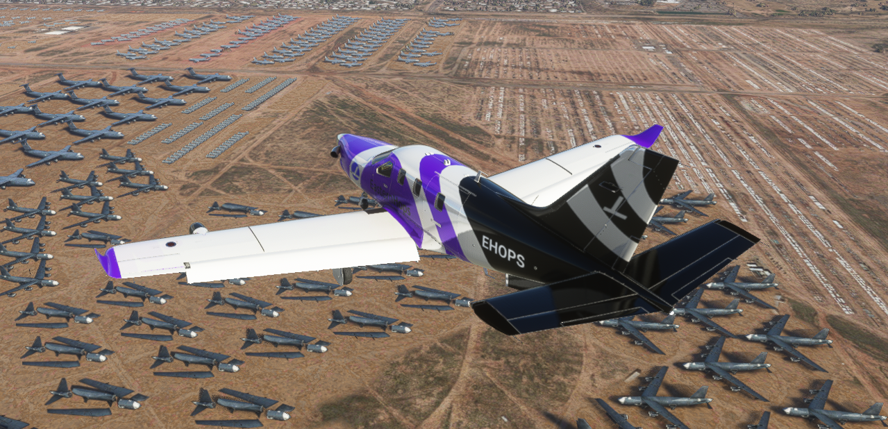
Here are some screenshots during live Cessna Hops on FS2020
Charlie S. VSA 0395
Pizza EH-4200
coldnebo
Pilots using Event Flight Tracker https://events.flighttracker.tech
Steff EH-313
Dickey Fuller
Hope to see you in our EasternHops Sky's